
Thank you for supporting this site ❤️
Make a donation
Make a donation
Hydra Island topographic map
Click on the map to display elevation.
Thank you for supporting this site ❤️
Make a donation
Make a donation
About this map
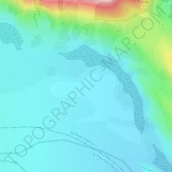
Name: Hydra Island topographic map, elevation, terrain.
Location: Hydra Island, Selwyn District, Canterbury, New Zealand (-43.27856 171.34181 -43.25856 171.36181)
Average elevation: 474 m
Minimum elevation: 441 m
Maximum elevation: 633 m
Thank you for supporting this site ❤️
Make a donation
Make a donation
Other topographic maps
Click on a map to view its topography, its elevation and its terrain.
Darfield
New Zealand > Canterbury > Selwyn District
Located on the Canterbury Plains at an altitude of 193 m (633 ft) above sea level, the Köppen-Geiger climate classification for Darfield is Cfb (Oceanic). On several days a year, Darfield is subject to the nor'west Foehn wind, which is very dry and has the capability to raise the temperature by several…
Average elevation: 198 m
Thank you for supporting this site ❤️
Make a donation
Make a donation
Thank you for supporting this site ❤️
Make a donation
Make a donation
Thank you for supporting this site ❤️
Make a donation
Make a donation