
Thank you for supporting this site ❤️
Make a donation
Make a donation
Redings Mill topographic map
Click on the map to display elevation.
Thank you for supporting this site ❤️
Make a donation
Make a donation
About this map
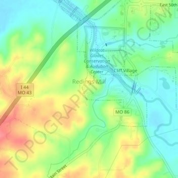
Name: Redings Mill topographic map, elevation, terrain.
Location: Redings Mill, Newton County, Missouri, United States (37.01490 -94.52351 37.02623 -94.51117)
Average elevation: 299 m
Minimum elevation: 271 m
Maximum elevation: 340 m
Thank you for supporting this site ❤️
Make a donation
Make a donation
Other topographic maps
Click on a map to view its topography, its elevation and its terrain.
Shoal Creek
United States > Missouri > Newton County > Joplin > Cliff Village
Average elevation: 295 m
Thank you for supporting this site ❤️
Make a donation
Make a donation