
Thank you for supporting this site ❤️
Make a donation
Make a donation
Big Cove Community topographic map
Click on the map to display elevation.
Thank you for supporting this site ❤️
Make a donation
Make a donation
About this map
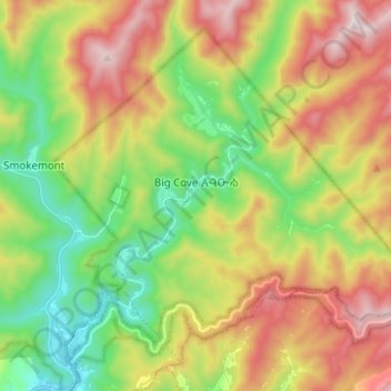
Name: Big Cove Community topographic map, elevation, terrain.
Average elevation: 1,009 m
Minimum elevation: 599 m
Maximum elevation: 1,564 m
Thank you for supporting this site ❤️
Make a donation
Make a donation
Other topographic maps
Click on a map to view its topography, its elevation and its terrain.
Cherokee
United States > North Carolina > Swain County > Yellowhill Community
Cherokee and its surrounding Qualla Boundary is in the very mountainous Swain and Jackson counties. The highest elevation is 6,643-foot (2,025 m) Clingman's Dome at the border with Tennessee. Clingman's Dome is the highest point in the Great Smoky Mountains National Park. The Oconaluftee River flows through…
Average elevation: 746 m
Thank you for supporting this site ❤️
Make a donation
Make a donation