
Thank you for supporting this site ❤️
Make a donation
Make a donation
Queets topographic map
Click on the map to display elevation.
Thank you for supporting this site ❤️
Make a donation
Make a donation
About this map
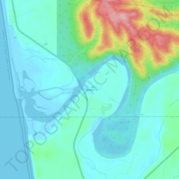
Name: Queets topographic map, elevation, terrain.
Location: Queets, Jefferson County, Washington, United States (47.51988 -124.35237 47.55988 -124.31237)
Average elevation: 36 m
Minimum elevation: -5 m
Maximum elevation: 167 m
Thank you for supporting this site ❤️
Make a donation
Make a donation
Other topographic maps
Click on a map to view its topography, its elevation and its terrain.