
Lake Turkana topographic map
Interactive map
Click on the map to display elevation.
Lake Turkana
The rocks of the surrounding area are predominantly volcanic. Central Island is an active volcano, emitting vapour. Outcrops and rocky shores are found on the east and south shores of the lake, while dunes, spits and flats are on the west and north, at a lower elevation.
About this map
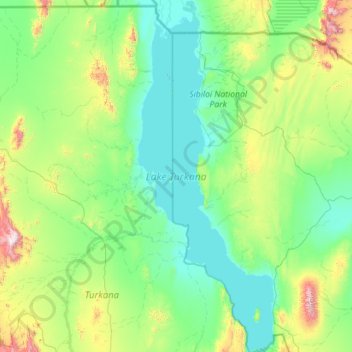
Name: Lake Turkana topographic map, elevation, terrain.
Location: Lake Turkana, Marsabit County, East Kenya, Kenya (2.39737 35.82914 4.65387 36.70775)
Average elevation: 590 m
Minimum elevation: 358 m
Maximum elevation: 2,270 m
Other topographic maps
Click on a map to view its topography, its elevation and its terrain.
Marsabit
Kenya > Marsabit County > Saku
Marsabit is a town in the northern Marsabit County in Kenya. It is situated in the former Eastern Province and is almost surrounded by the Marsabit National Park. The town is located 170 kilometres (110 mi) east of the centre of the East African Rift at an elevation of between 1300 and 1400 metres. It serves…
Average elevation: 1,346 m