
Make a donation
Highest Point topographic map
Click on the map to display elevation.
Make a donation
About this map
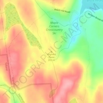
Name: Highest Point topographic map, elevation, terrain.
Average elevation: 389 m
Minimum elevation: 322 m
Maximum elevation: 438 m
Make a donation
Other topographic maps
Click on a map to view its topography, its elevation and its terrain.
Springfield
United States > Massachusetts > Hampden County
Aside from its rivers, Springfield's second most prominent topographical feature is the city's 735-acre (297 ha) Forest Park. Forest Park lies in the southwestern corner of the city, surrounded by Springfield's attractive garden districts, Forest Park and Forest Park Heights, which feature over 600 Victorian…
Average elevation: 50 m
Make a donation
Holland
United States > Massachusetts > Hampden County
Holland is located in the southeast corner of Hampden County in western Massachusetts. It is drained by the Quinebaug River and contains the Hamilton Reservoir, one of the largest reservoirs in southern New England. The town is nestled amongst two hill ranges, where elevations reach up to greater than 1,100…
Average elevation: 257 m
Palmer
United States > Massachusetts > Hampden County
Palmer Motor Sports Park opened for racing in May 2015. It is a 2.3 mile road course with over 190 feet in elevation change. Road & Track magazine named Palmer Motorsports Park one of the top 10 racetracks to drive in North America.
Average elevation: 154 m
Make a donation
Make a donation
Chicopee
United States > Massachusetts > Hampden County
Willimansett, and portions of the Center and Falls are on low land, with Aldenville, Fairview, Westover, and the Burnett Road neighborhoods on an elevated plateau. At 288 feet, the highest elevation in the city is on Old Lyman Road, in the Fairview section.
Average elevation: 67 m
Blandford
United States > Massachusetts > Hampden County
The town is located near the eastern edge of the Berkshire Hills, above an ancient rift zone where the Connecticut River Valley is downfaulted about 1,000 feet (300 m). The town's elevations range from about 400 feet (120 m) above sea level along streams approaching the Westfield River (a major tributary of…
Average elevation: 383 m
Make a donation
Russell
United States > Massachusetts > Hampden County
The town has two very different sections: South Quarter is mainly uplands at elevations from 1,000 to 1,400 feet (300 to 430 m) along the rim of a plateau west of the Connecticut River Valley, while the rest of the town is a deep valley along the swift Westfield River.
Average elevation: 249 m
Make a donation
Make a donation
Make a donation
Springfield
United States > Massachusetts > Hampden County
Aside from its rivers, Springfield's second most prominent topographical feature is the city's 735-acre (297 ha) Forest Park. Forest Park lies in the southwestern corner of the city, surrounded by Springfield's attractive garden districts, Forest Park and Forest Park Heights, which feature over 600 Victorian…
Average elevation: 50 m
Blandford
United States > Massachusetts > Hampden County
The town is located near the eastern edge of the Berkshire Hills, above an ancient rift zone where the Connecticut River Valley is downfaulted approximately 1,000 feet (300 m). The town's elevations range from about 400 feet (120 m) above sea level along streams approaching the Westfield River (a major…
Average elevation: 346 m
Granville State Forest
United States > Massachusetts > Hampden County > Granville
Average elevation: 373 m
Make a donation
Palmer
United States > Massachusetts > Hampden County
Palmer Motor Sports Park opened for racing in May 2015. It is a 2.3 mile road course with over 190 feet in elevation change. Road & Track magazine named Palmer Motorsports Park one of the top 10 racetracks to drive in North America.
Average elevation: 154 m
Springfield
United States > Massachusetts > Hampden County
Aside from its rivers, Springfield's second most prominent topographical feature is the city's 735-acre (297 ha) Forest Park. Forest Park lies in the southwestern corner of the city, surrounded by Springfield's attractive garden districts, Forest Park and Forest Park Heights, which feature over 600 Victorian…
Average elevation: 50 m
Victory Lake Dam
United States > Massachusetts > Hampden County > Camp Spruce Hill
Average elevation: 317 m
Make a donation
Blandford
United States > Massachusetts > Hampden County
The town is located near the eastern edge of the Berkshire Hills, above an ancient rift zone where the Connecticut River Valley is downfaulted approximately 1,000 feet (300 m). The town's elevations range from about 400 feet (120 m) above sea level along streams approaching the Westfield River (a major…
Average elevation: 346 m
Make a donation
Springfield
United States > Massachusetts > Hampden County
Aside from its rivers, Springfield's second most prominent topographical feature is the city's 735-acre (297 ha) Forest Park. Forest Park lies in the southwestern corner of the city, surrounded by Springfield's attractive garden districts, Forest Park and Forest Park Heights, which feature over 600 Victorian…
Average elevation: 50 m
Make a donation
Chicopee
United States > Massachusetts > Hampden County
Willimansett, and portions of the Center and Falls are on low land, with Aldenville, Fairview, Westover, and the Burnett Road neighborhoods on an elevated plateau. At 288 feet, the highest elevation in the city is on Old Lyman Road, in the Fairview section.
Average elevation: 67 m
Hampden
United States > Massachusetts > Hampden County > Hampden
According to the United States Census Bureau, the town has a total area of 19.6 square miles (51 km2), of which 19.6 square miles (51 km2) is land and 0.05% is water. Hampden is located at the eastern edge of the Connecticut River Valley. Hills rise up to over 1,000 feet (300 m) above sea level, from the…
Average elevation: 143 m
Make a donation