
Make a donation
Blandford topographic map
Click on the map to display elevation.
Make a donation
Blandford
The town is located near the eastern edge of the Berkshire Hills, above an ancient rift zone where the Connecticut River Valley is downfaulted approximately 1,000 feet (300 m). The town's elevations range from about 400 feet (120 m) above sea level along streams approaching the Westfield River (a major tributary of the Connecticut) to hilltops as high as 1,700 feet (520 m). Elevations increase to the west with expansive views eastward across the Connecticut River Valley as far as Mount Monadnock in southern New Hampshire. Local relief is as high as 500 feet (150 m) near streams flowing into the Westfield River, but away from these streams the town is characterised by rolling uplands.
Make a donation
About this map
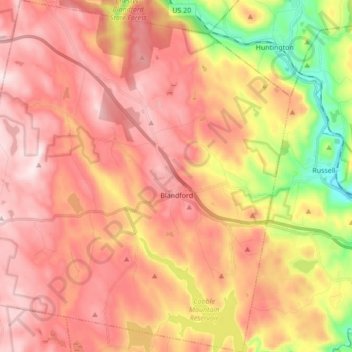
Name: Blandford topographic map, elevation, terrain.
Average elevation: 346 m
Minimum elevation: 72 m
Maximum elevation: 523 m
Make a donation
Other topographic maps
Click on a map to view its topography, its elevation and its terrain.
Make a donation
Make a donation
Make a donation
Victory Lake Dam
United States > Massachusetts > Hampden County > Camp Spruce Hill
Average elevation: 317 m
Make a donation
Make a donation
Make a donation