
Thank you for supporting this site ❤️
Make a donation
Make a donation
Illahee topographic map
Click on the map to display elevation.
Thank you for supporting this site ❤️
Make a donation
Make a donation
About this map
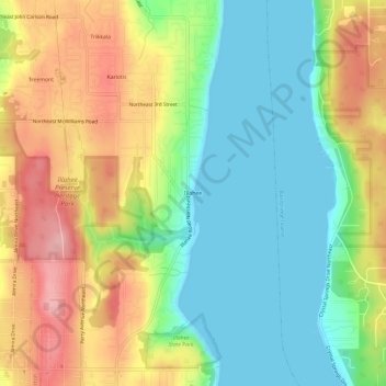
Name: Illahee topographic map, elevation, terrain.
Location: Illahee, Kitsap County, Washington, 98310, United States (47.59387 -122.61620 47.63387 -122.57620)
Average elevation: 62 m
Minimum elevation: -1 m
Maximum elevation: 152 m
Thank you for supporting this site ❤️
Make a donation
Make a donation
Other topographic maps
Click on a map to view its topography, its elevation and its terrain.
Manitou Beach Park
United States > Washington > Kitsap County > Bainbridge Island
Average elevation: 27 m
Thank you for supporting this site ❤️
Make a donation
Make a donation
Bainbridge Island
United States > Washington > Kitsap County > Bainbridge Island
Average elevation: 29 m
Thank you for supporting this site ❤️
Make a donation
Make a donation