
Thank you for supporting this site ❤️
Make a donation
Make a donation
Manchester topographic map
Click on the map to display elevation.
Thank you for supporting this site ❤️
Make a donation
Make a donation
About this map
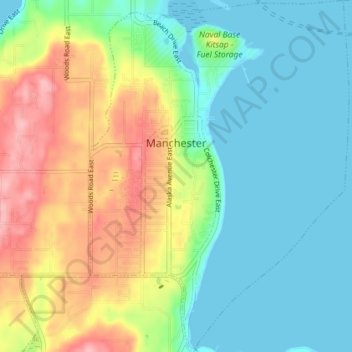
Name: Manchester topographic map, elevation, terrain.
Average elevation: 42 m
Minimum elevation: 0 m
Maximum elevation: 122 m
Thank you for supporting this site ❤️
Make a donation
Make a donation
Other topographic maps
Click on a map to view its topography, its elevation and its terrain.
Thank you for supporting this site ❤️
Make a donation
Make a donation
Manitou Beach Park
United States > Washington > Kitsap County > Bainbridge Island
Average elevation: 27 m
Thank you for supporting this site ❤️
Make a donation
Make a donation
Thank you for supporting this site ❤️
Make a donation
Make a donation
Thank you for supporting this site ❤️
Make a donation
Make a donation
Striebels Corner
United States > Washington > Kitsap County > Striebels Corner
Average elevation: 48 m