
Make a donation
Kitui County topographic map
Click on the map to display elevation.
Make a donation
About this map
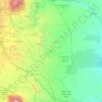
Name: Kitui County topographic map, elevation, terrain.
Location: Kitui County, Eastern, Kenya (-3.07075 37.59553 -0.05543 39.07612)
Average elevation: 764 m
Minimum elevation: 67 m
Maximum elevation: 5,785 m
Make a donation
Other topographic maps
Click on a map to view its topography, its elevation and its terrain.
Murang'a
Kenya > Murang'a County > Kiharu
The town is low, hilly, small but picturesque with an altitude of 4120 ft (1255 metres) above sea level. As a result of the varying altitudes, Murang'a can get quite cold from May to mid-August, and can experience hail. To the west of the town are the rolling Kikuyu farmlands that extend into the distance.
Average elevation: 1,286 m
Make a donation
Make a donation
Make a donation
Marsabit
Kenya > Marsabit County > Saku
Marsabit is a town in the northern Marsabit County in Kenya. It is situated in the former Eastern Province and is almost surrounded by the Marsabit National Park. The town is located 170 kilometres (110 mi) east of the centre of the East African Rift at an elevation of between 1300 and 1400 metres. It serves…
Average elevation: 1,346 m
Make a donation
Make a donation
Make a donation
Make a donation
Makindu
Kenya > Makueni > Kibwezi West
Makindu has an altitude-moderated hot semi-arid climate (Köppen BSh) with very warm to hot afternoons and pleasant mornings throughout the year. Like most of Kenya, there are two rainy seasons: the “long rains” in March and April, and the “short rains” centred on November and December.
Average elevation: 993 m
Make a donation
Nyahururu
Kenya > Laikipia County > Laikipia West
Nyahururu is also frequented by marathon and cross-country runners for practicing before major events due to its high altitude.
Average elevation: 2,348 m
Make a donation
Mombasa
Kenya > Mombasa County > Mvita
Being a coastal town, Mombasa is characterised by a flat topography. The town of Mombasa is centred on Mombasa Island, but extends to the mainland. The island is separated from the mainland by two creeks, Port Reitz in the south and Tudor Creek in the north.
Average elevation: 32 m