
Thank you for supporting this site ❤️
Make a donation
Make a donation
Flinders Island topographic map
Click on the map to display elevation.
Thank you for supporting this site ❤️
Make a donation
Make a donation
About this map
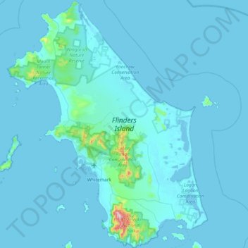
Name: Flinders Island topographic map, elevation, terrain.
Location: Flinders Island, Tasmania, 7255, Australia (-40.27409 147.74817 -39.71955 148.33210)
Average elevation: 20 m
Minimum elevation: -3 m
Maximum elevation: 737 m
Thank you for supporting this site ❤️
Make a donation
Make a donation
Other topographic maps
Click on a map to view its topography, its elevation and its terrain.