
Rhone topographic map
Interactive map
Click on the map to display elevation.
About this map
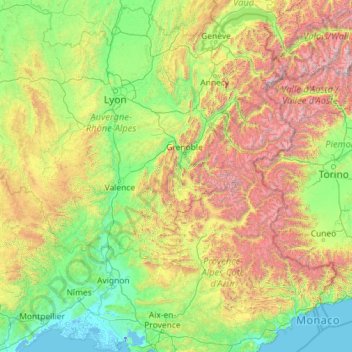
Name: Rhone topographic map, elevation, terrain.
Location: Rhone, Metropolitan France, 01150, France (43.33408 4.59821 46.57906 8.38366)
Average elevation: 842 m
Minimum elevation: -12 m
Maximum elevation: 4,502 m
Other topographic maps
Click on a map to view its topography, its elevation and its terrain.
Pointe de Chardonnière
France > Auvergne-Rhône-Alpes > Upper Savoy > Sixt-Fer-à-Cheval
Average elevation: 2,128 m
Val Thorens
France > Auvergne-Rhône-Alpes > Savoy > Val Thorens
The resort hosted a Tour de France stage finish in 1994. Nelson Rodriguez of Colombia won the stage, which had the second highest elevation for a stage finish in the history of the Tour de France.
Average elevation: 2,516 m
Santez Anna
France > Brittany > Côtes-d'Armor > Bulat-Pestivien > Santez Anna
Average elevation: 250 m
Faubourg Scarafaglie
France > Corsica > Haute-Corse > Corte > Faubourg Scarafaglie
Average elevation: 580 m
Îlet à Malheur les Hauts
France > Réunion > La Possession > Îlet à Malheur les Hauts
Average elevation: 1,002 m