
Make a donation
Mount Pleasant topographic map
Click on the map to display elevation.
Make a donation
About this map
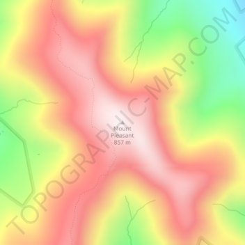
Name: Mount Pleasant topographic map, elevation, terrain.
Average elevation: 600 m
Minimum elevation: 236 m
Maximum elevation: 851 m
Make a donation
Other topographic maps
Click on a map to view its topography, its elevation and its terrain.
Washington Heights
United States > New York > New York
Because of their abrupt, hilly topography, pedestrian navigation in Upper Manhattan is facilitated by many step streets. The longest of these in Washington Heights, at approximately 130 stairs and with an elevation gain of approximately 65 feet, connects Fort Washington Avenue and Overlook Terrace at 187th…
Average elevation: 25 m
Make a donation
Town of East Greenbush
United States > New York > Rensselaer County
The western section of the town, along the Hudson River is marked by bluffs that rise to an elevation of between 100 and 300 feet. The little flat land that exists along the river is on the Papscanee Island. Papscanee Island is actually a peninsula, separated from the rest of the town by the Papscanee Creek.…
Average elevation: 89 m
Catskill Park
New York's wilderness areas must be composed of 10,000 acres (4,000 ha; 40 km2) of contiguous land, twice the federal standard. Land is to be left as "untrammeled by man" and as close to its natural state as possible, offering outstanding opportunities for solitude. No artificially-powered devices are…
Average elevation: 501 m
Make a donation
Town of Mendon
United States > New York > Monroe County
The town is bordered on the north by the town of Pittsford, on the west by the towns of Henrietta and Rush, and on the south and east by Ontario County. Honeoye Creek enters across the southern town line. The town is made up mostly of horse farms and family homes. The highest elevations in Monroe County are in…
Average elevation: 205 m
Port Jefferson Station
United States > New York > Suffolk County > Town of Brookhaven
Average elevation: 48 m
Harriman State Park
United States > New York > Orange County > Town of Tuxedo
Average elevation: 219 m
Make a donation
Village of Warwick
United States > New York > Orange County > Town of Warwick
Average elevation: 187 m
Make a donation
Make a donation
Make a donation
Make a donation
Genesee River
Only a small creek (Irondequoit Creek) flows in what is left of this large paleogeologic valley. The area of the lower river was also affected. Since the earth rebounded from the melting glaciers more rapidly in Canada than in New York, water from Lake Ontario was spilled over New York due to its lower…
Average elevation: 397 m
Make a donation
Make a donation
Town of Mamakating
United States > New York > Sullivan County
The highest elevation in the town is 1,648 feet (502 m), near the junction of Mamakating Avenue and Park Road in the Mamakating Park Historic District. The lowest elevation is 340 feet (100 m), at the tripoint with Orange and Ulster counties where the Bush Kill drains into the Shawangunkill.
Average elevation: 316 m
Make a donation
Thornwood
United States > New York > Westchester County > Town of Mount Pleasant
Average elevation: 121 m
Mohonk Mountain House Property
United States > New York > Ulster County > Town of New Paltz
Average elevation: 228 m
Make a donation
Onondaga Escarpment
United States > New York > Erie County > Harris Hill > Town of Clarence > Eastern Hills
Average elevation: 205 m
Make a donation
Village of New Paltz
United States > New York > Ulster County > Town of New Paltz
Average elevation: 84 m
Make a donation
Make a donation
Village of Valley Stream
United States > New York > Nassau County
At this time, the community did not have a post office, so residents had to pick up their mail in the village of Hempstead. After Pagan petitioned authorities for a post office, he was appointed postmaster and it was based in his farmhouse, now known as the Pagan-Fletcher House. He was advised that the…
Average elevation: 7 m
Make a donation
Village of Elmira Heights
United States > New York > Chemung County > Town of Horseheads
Average elevation: 278 m
Lake Mohansic
United States > New York > Westchester County > Town of Yorktown
Average elevation: 159 m
Make a donation
Make a donation
Village of Cassadaga
United States > New York > Chautauqua County > Town of Stockton
Cassadaga is located on the northwestern edge of the Allegheny Plateau in western New York at 42°20'29" north, 79°18'56" west (42.341343, -79.315653) at an elevation of approximately 1,340 feet (410 m) above sea level. The village is located at the south end of Lower Cassadaga Lake, Lily Dale being located…
Average elevation: 418 m
Make a donation
Make a donation
Charles E. Baker State Forest
United States > New York > Madison County > Town of Brookfield
Average elevation: 482 m
Murray Isle
United States > New York > Jefferson County > Town of Clayton > Grenell
Average elevation: 78 m
Make a donation
Make a donation
Make a donation
Make a donation
Make a donation
Make a donation