
Make a donation
Genesee River topographic map
Click on the map to display elevation.
Make a donation
Genesee River
Only a small creek (Irondequoit Creek) flows in what is left of this large paleogeologic valley. The area of the lower river was also affected. Since the earth rebounded from the melting glaciers more rapidly in Canada than in New York, water from Lake Ontario was spilled over New York due to its lower elevation. During this time, the original outlet of the Genesee River, Irondequoit Bay, was flooded out, creating the current bay. As these waters later retreated, glacial debris caused the river to be rerouted to the west along its current path.
Make a donation
About this map
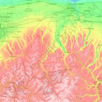
Name: Genesee River topographic map, elevation, terrain.
Location: Genesee River, New York, United States (41.88866 -78.16955 43.26328 -77.59842)
Average elevation: 397 m
Minimum elevation: 73 m
Maximum elevation: 789 m
Make a donation
Other topographic maps
Click on a map to view its topography, its elevation and its terrain.
Saratoga Springs
United States > New York > Saratoga County > Saratoga Springs
Average elevation: 161 m
Troy
United States > New York > Rensselaer County
The western edge of the city is flat along the river, and then steeply slopes to higher terrain to the east. The average elevation is 50 feet, with the highest elevation being 500 feet in the eastern part of the city. The city is longer than it is wide, with the southern part wider than the northern section of…
Average elevation: 137 m
Make a donation
Make a donation
Sag Harbor
United States > New York > Suffolk County > Sag Harbor > Sag Harbor
Average elevation: 13 m
Make a donation
Make a donation
Make a donation
Make a donation
Woods Mills
United States > New York > Clinton County > Town of Schuyler Falls
Average elevation: 211 m
Make a donation
Stony Brook University
United States > New York > Suffolk County > Town of Brookhaven
Average elevation: 46 m
East Hampton
United States > New York > Suffolk County > East Hampton > Village of East Hampton
Average elevation: 12 m
Erie Canal
United States > New York > Erie County > City of Tonawanda
The construction of the Erie Canal was a landmark civil engineering achievement in the early history of the United States. When built, the 363-mile (584 km) canal was the second-longest in the world (after the Grand Canal in China). Initially 40 feet (12 m) wide and 4 feet (1.2 m) deep, the canal was expanded…
Average elevation: 177 m
Make a donation
Ellenburg Center
United States > New York > Clinton County > Town of Ellenburg
Average elevation: 383 m
Make a donation
Gloversville
United States > New York > Gloversville
The city sits in the foothills of the Adirondack Mountains and therefore is within a climatic transition zone. Gloversville experiences the warmer summer temperatures common throughout the Capital Region's Hudson and Mohawk Valleys while experiencing generally more copious precipitation throughout the year…
Average elevation: 275 m
Make a donation
Make a donation
Lake Mohansic
United States > New York > Westchester County > Town of Yorktown
Average elevation: 159 m
Lower Corners
United States > New York > Schenectady County > Town of Glenville
Average elevation: 205 m
Make a donation
Van Buren Point
United States > New York > Chautauqua County > Town of Portland
Average elevation: 177 m
Irving
United States > New York > Chautauqua County
Irving is a hamlet in Chautauqua County, New York, United States. (It also falls in Cattaraugus County and Erie County. The Cattaraugus County part of Irving is part of the Seneca Nation Native American territory, the Erie County part borders Brant, New York and also is part of the Seneca Nation territory. )…
Average elevation: 185 m
Make a donation
Findley Lake
United States > New York > Chautauqua County
Findley Lake is part of the town of Mina in southwestern Chautauqua County, New York, United States. Situated at an elevation of 1440 ft (439 m) above sea level, this hamlet is located on the north shore of Findley Lake.
Average elevation: 463 m
Murray Isle
United States > New York > Jefferson County > Town of Clayton > Grenell
Average elevation: 78 m
Make a donation
Dewittville
United States > New York > Chautauqua County > Town of Chautauqua
Average elevation: 425 m
Make a donation
Make a donation
Make a donation
Owasco Lake Station
United States > New York > Cayuga County > Town of Fleming
Average elevation: 252 m
Make a donation
Make a donation
Make a donation
Make a donation
Make a donation
Make a donation
Make a donation
Make a donation