
Thank you for supporting this site ❤️
Make a donation
Make a donation
Charlton Down topographic map
Click on the map to display elevation.
Thank you for supporting this site ❤️
Make a donation
Make a donation
About this map
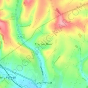
Name: Charlton Down topographic map, elevation, terrain.
Location: Charlton Down, Dorset, England, DT2 9RJ, United Kingdom (50.73073 -2.47649 50.77073 -2.43649)
Average elevation: 107 m
Minimum elevation: 60 m
Maximum elevation: 171 m
Thank you for supporting this site ❤️
Make a donation
Make a donation
Other topographic maps
Click on a map to view its topography, its elevation and its terrain.
Thank you for supporting this site ❤️
Make a donation
Make a donation
Thank you for supporting this site ❤️
Make a donation
Make a donation