
Thank you for supporting this site ❤️
Make a donation
Make a donation
Kaitangata topographic map
Click on the map to display elevation.
Thank you for supporting this site ❤️
Make a donation
Make a donation
About this map
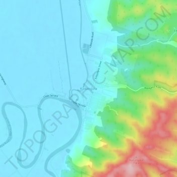
Name: Kaitangata topographic map, elevation, terrain.
Location: Kaitangata, Clutha District, Otago, 9210, New Zealand (-46.30174 169.82641 -46.26174 169.86641)
Average elevation: 45 m
Minimum elevation: -1 m
Maximum elevation: 212 m
Thank you for supporting this site ❤️
Make a donation
Make a donation
Other topographic maps
Click on a map to view its topography, its elevation and its terrain.