
Thank you for supporting this site ❤️
Make a donation
Make a donation
Diamond topographic map
Click on the map to display elevation.
Thank you for supporting this site ❤️
Make a donation
Make a donation
About this map
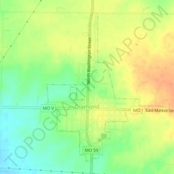
Name: Diamond topographic map, elevation, terrain.
Location: Diamond, Newton County, Missouri, United States (36.98684 -94.32388 37.00984 -94.30078)
Average elevation: 354 m
Minimum elevation: 332 m
Maximum elevation: 373 m
Thank you for supporting this site ❤️
Make a donation
Make a donation
Other topographic maps
Click on a map to view its topography, its elevation and its terrain.
Shoal Creek
United States > Missouri > Newton County > Joplin > Cliff Village
Average elevation: 295 m
Thank you for supporting this site ❤️
Make a donation
Make a donation