
Thank you for supporting this site ❤️
Make a donation
Make a donation
Scottdale topographic map
Click on the map to display elevation.
Thank you for supporting this site ❤️
Make a donation
Make a donation
About this map
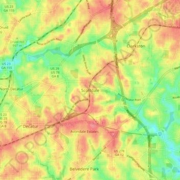
Name: Scottdale topographic map, elevation, terrain.
Location: Scottdale, DeKalb County, Georgia, 30079, United States (33.74983 -84.30409 33.82983 -84.22409)
Average elevation: 302 m
Minimum elevation: 263 m
Maximum elevation: 334 m
Thank you for supporting this site ❤️
Make a donation
Make a donation
Other topographic maps
Click on a map to view its topography, its elevation and its terrain.