
Thank you for supporting this site ❤️
Make a donation
Make a donation
Doraville topographic map
Click on the map to display elevation.
Thank you for supporting this site ❤️
Make a donation
Make a donation
About this map
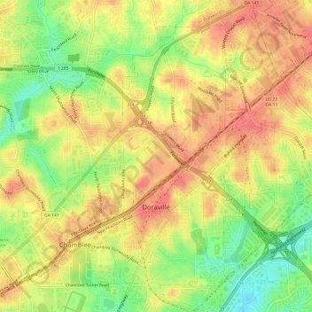
Name: Doraville topographic map, elevation, terrain.
Location: Doraville, DeKalb County, Georgia, 30063, United States (33.88141 -84.29086 33.93121 -84.23861)
Average elevation: 307 m
Minimum elevation: 271 m
Maximum elevation: 330 m
Thank you for supporting this site ❤️
Make a donation
Make a donation
Other topographic maps
Click on a map to view its topography, its elevation and its terrain.
Thank you for supporting this site ❤️
Make a donation
Make a donation
Thank you for supporting this site ❤️
Make a donation
Make a donation
Thank you for supporting this site ❤️
Make a donation
Make a donation