
Thank you for supporting this site ❤️
Make a donation
Make a donation
Howe Sound topographic map
Click on the map to display elevation.
Thank you for supporting this site ❤️
Make a donation
Make a donation
About this map
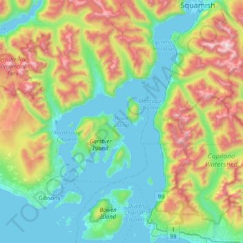
Name: Howe Sound topographic map, elevation, terrain.
Average elevation: 529 m
Minimum elevation: -2 m
Maximum elevation: 1,945 m
Thank you for supporting this site ❤️
Make a donation
Make a donation
Other topographic maps
Click on a map to view its topography, its elevation and its terrain.
Mount Wrottesley
Canada > British Columbia > Sunshine Coast Regional District > Area F (West Howe Sound)
Average elevation: 1,076 m