
Thank you for supporting this site ❤️
Make a donation
Make a donation
Manly topographic map
Click on the map to display elevation.
Thank you for supporting this site ❤️
Make a donation
Make a donation
About this map
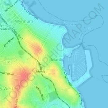
Name: Manly topographic map, elevation, terrain.
Location: Manly, Greater Brisbane, Queensland, Australia (-27.46316 153.17483 -27.44350 153.19993)
Average elevation: 13 m
Minimum elevation: 0 m
Maximum elevation: 50 m
Thank you for supporting this site ❤️
Make a donation
Make a donation
Other topographic maps
Click on a map to view its topography, its elevation and its terrain.