
Thank you for supporting this site ❤️
Make a donation
Make a donation
Townsville topographic map
Click on the map to display elevation.
Thank you for supporting this site ❤️
Make a donation
Make a donation
About this map
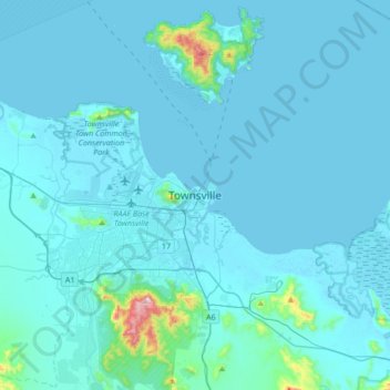
Name: Townsville topographic map, elevation, terrain.
Location: Townsville, Townsville City, Queensland, 4810, Australia (-19.41694 146.66395 -19.09694 146.98395)
Average elevation: 30 m
Minimum elevation: -3 m
Maximum elevation: 579 m
Thank you for supporting this site ❤️
Make a donation
Make a donation
Other topographic maps
Click on a map to view its topography, its elevation and its terrain.
Thank you for supporting this site ❤️
Make a donation
Make a donation
Thank you for supporting this site ❤️
Make a donation
Make a donation
Warwick
Warwick experiences an altitude-influenced humid subtropical climate (Köppen: Cfa), with hot summers and mild, relatively dry winters with cold nights. Annual precipitation averages 662.4 millimetres (26.08 in), with a summer maximum. The town is slightly cooler and less humid than the proximate southeast…
Average elevation: 474 m