
Make a donation
Bushland topographic map
Click on the map to display elevation.
Make a donation
Bushland
Bushland is located at 35°11′31″N 102°03′53″W / 35.19194°N 102.06472°W / 35.19194; -102.06472 (35.1919978, -102.0646392), at an elevation of 3,825 feet. The community is situated along Interstate 40, approximately 14 miles west of Amarillo in southwestern Potter County.
Make a donation
About this map
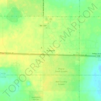
Name: Bushland topographic map, elevation, terrain.
Location: Bushland, Potter County, Texas, 79012, United States (35.17289 -102.08038 35.21289 -102.04038)
Average elevation: 1,166 m
Minimum elevation: 1,152 m
Maximum elevation: 1,175 m
Make a donation
Other topographic maps
Click on a map to view its topography, its elevation and its terrain.
Amarillo
United States > Texas > Potter County
Extreme temperatures range from −16 °F (−26.7 °C) on February 12, 1899 to 111 °F (43.9 °C) on June 26, 2011, but lows do not typically dip to 0 °F or −17.8 °C in most years, while highs above 100 °F or 37.8 °C are seen on 4.7 days on average. On average, there are 5.9 days of lows at or below 10…
Average elevation: 1,097 m
Alibates Flint Quarries National Monument
United States > Texas > Potter County
Average elevation: 947 m