
Thank you for supporting this site ❤️
Make a donation
Make a donation
Miller Mountian topographic map
Click on the map to display elevation.
Thank you for supporting this site ❤️
Make a donation
Make a donation
About this map
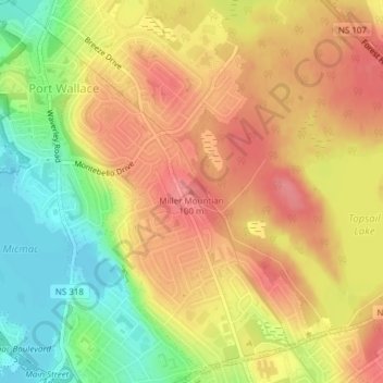
Name: Miller Mountian topographic map, elevation, terrain.
Average elevation: 64 m
Minimum elevation: 17 m
Maximum elevation: 98 m
Thank you for supporting this site ❤️
Make a donation
Make a donation
Other topographic maps
Click on a map to view its topography, its elevation and its terrain.
Sable Island
Canada > Nova Scotia > Halifax County > Sable Island
Sable Island is a narrow, crescent-shaped sandbar with a surface area estimated around 34 km2 (13 sq mi). Despite being approximately 43.15 km (26.81 mi) long, it is only 1.21 km (0.75 mi) across at its widest point. The maximum elevation is about 30 m (98 ft). The long crescent-shaped island rises gently from…
Average elevation: 0 m
Thank you for supporting this site ❤️
Make a donation
Make a donation
Thank you for supporting this site ❤️
Make a donation
Make a donation
Colby Village Elementary School Park
Canada > Nova Scotia > Halifax County > Cole Harbour
Average elevation: 54 m
Thank you for supporting this site ❤️
Make a donation
Make a donation
Thank you for supporting this site ❤️
Make a donation
Make a donation
Thank you for supporting this site ❤️
Make a donation
Make a donation
Thank you for supporting this site ❤️
Make a donation
Make a donation