
Make a donation
Santa Cruz Mountains topographic map
Click on the map to display elevation.
Make a donation
Santa Cruz Mountains
The Santa Cruz Mountains are a region of great biological diversity, encompassing cool, moist coastal ecosystems as well as warm, dry chaparral. Much of the area in the Santa Cruz mountains is considered temperate rainforest. In valleys and moist ocean-facing slopes some of the southernmost coast redwoods grow, along with coast Douglas-fir. Coast live oak, Pacific madrone, Pacific wax myrtle, big leaf maple, California bay laurel, and California black oak also occur in the Santa Cruz Mountains. There do exist several small and isolated stands of old-growth forest, most notably at Henry Cowell Redwoods and Portola Redwoods State Parks and one sizeable old-growth redwood forest at Big Basin. At higher elevations and on sunny south slopes a more drought-resistant chaparral vegetation dominates: manzanita, California scrub oak, chamise, and chaparral pea. Spring wildflowers are also widespread throughout the range.
Make a donation
About this map
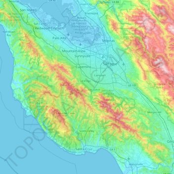
Name: Santa Cruz Mountains topographic map, elevation, terrain.
Location: Santa Cruz Mountains, California, 95033, United States (36.91020 -122.50631 37.72645 -121.56010)
Average elevation: 210 m
Minimum elevation: -4 m
Maximum elevation: 1,265 m
Make a donation
Other topographic maps
Click on a map to view its topography, its elevation and its terrain.
Stanislaus County
There are a number or rare and endangered species found in Stanislaus County. The Beaked Clarkia, (Clarkia rostrata), is listed as a candidate for the Federal Endangered Species List. It has only been found in blue oak-gray pine associations in the foothills of the Sierra Nevada, a habitat which occurs at…
Average elevation: 151 m
Death Valley National Park
United States > California > Inyokern
There are two major valleys in the park, Death Valley and Panamint Valley. Both of these valleys were formed within the last few million years and both are bounded by north–south-trending mountain ranges. These and adjacent valleys follow the general trend of Basin and Range topography with one modification:…
Average elevation: 1,177 m
Indio
United States > California > Riverside County
Indio is home of Riverside County's eastern administration offices. Palm Springs had more people from 1955 to 1992, when the US census announced that Indio surpassed Palm Springs and that title was returned to them. The official elevation of Indio is below sea level; the city hall is 14 feet (4 m) below sea…
Average elevation: 74 m
Desert Hot Springs
United States > California > Riverside County
Summer winds and the higher elevation keep Desert Hot Springs on average 5-7 degrees cooler than other communities in Coachella Valley. However, the winter season can be warmer due to the surrounding mountains blocking north winds. Since it lies at a higher elevation than the cities further south, cold air…
Average elevation: 498 m
Make a donation
Plumas County
In 1850, African-American frontiersman James Beckwourth discovered the lowest pass through the Sierras, which became known as Beckwourth Pass. Using the pass, he blazed a trail from Western Nevada through much of Plumas County, eventually terminating in the Sacramento Valley. Many erstwhile miners followed…
Average elevation: 1,560 m
Make a donation
Camarillo
United States > California > Ventura County
In the mid-1950s, the Ventura Freeway was completed from Los Angeles to points north, making it an easy one-hour trip to Camarillo. The Old Town was bisect by the Ventura Freeway. On the southern side of the freeway contains a strip of businesses, churches, schools, and parks. The freeway was originally…
Average elevation: 90 m
Mojave
United States > California > Kern County
Mojave (formerly Mohave) is an unincorporated community in Kern County, California, United States. Mojave is located 50 miles (80 km) east of Bakersfield, and 100 miles (161 km) north of Los Angeles, at an elevation of 2,762 feet (842 m). The town is located in the western region of the Mojave Desert, below…
Average elevation: 857 m
Palm Springs
United States > California > Riverside County
One possible origin of palm in the place name comes from early Spanish explorers who referred to the area as La Palma de la Mano de Dios or "The Palm of God's hand". The earliest use of the name "Palm Springs" is from United States Topographical Engineers who used the term in 1853 maps. According to William…
Average elevation: 859 m
Make a donation
Ridgecrest
United States > California > Kern County
Walker Pass (elevation 5,250 ft (1.60 km)) is a mountain pass by Lake Isabella in the southern Sierra Nevada mountains. It is located in northeastern Kern County, approximately 53 mi (85 km) ENE of Bakersfield and 10 mi (16 km) WSW of Ridgecrest. The pass provides a route between the San Joaquin Valley on the…
Average elevation: 740 m
Make a donation
El Cerrito
United States > California > Contra Costa County
According to the United States Census Bureau, the city has a total area of 3.7 square miles (9.6 km2), all of it land. The city ranges in elevation from 20 to 934 feet, with an average elevation of 69 feet (21 m).
Average elevation: 91 m
Make a donation
Lake Tahoe
United States > California > Placer County
Lake Tahoe has a dry-summer continental climate (Dsb in the Köppen climate classification), featuring warm, dry summers and chilly winters with regular snowfall. Mean annual precipitation ranges from over 55 inches (1,400 mm) for watersheds on the west side of the basin to about 26 inches (660 mm) near the…
Average elevation: 2,077 m
Make a donation
Make a donation
Kings Canyon National Park
United States > California > Fresno County
Kings Canyon is characterized by some of the steepest vertical relief in North America, with numerous peaks over 14,000 feet (4,300 m) on the Sierra Crest along the park's eastern border, falling to 4,500 feet (1,400 m) in the valley floor of Cedar Grove just ten miles (16 km) to the west. The Sierran crest…
Average elevation: 2,591 m
Fort Irwin
United States > California > San Bernardino County
Fort Irwin National Training Center (Fort Irwin NTC) is a major training area for the United States military in the Mojave Desert in northern San Bernardino County, California. Fort Irwin is at an average elevation of 2,454 feet (748 m). It is located 37 miles (60 km) northeast of Barstow, in the Calico…
Average elevation: 785 m
Make a donation
Montara
United States > California > San Mateo County
The rare and endangered species Hickman's potentilla occurs at the northern extremity of Montara on the slopes above Martini Creek at elevations ranging from 32 to 410 ft (9.8 to 125.0 m).
Average elevation: 66 m
Make a donation
Hayfork
United States > California > Trinity County
Hayfork is located at 40°34′17″N 123°8′48″W / 40.57139°N 123.14667°W / 40.57139; -123.14667 (40.571406, -123.146619) at an elevation of 2310 feet.
Average elevation: 1,049 m
Santa Rosa and San Jacinto Mountains National Monument
United States > California > Riverside County
The differences in elevation, temperature, and moisture give rise to diverse vegetation. Being the western boundary of the Sonoran Desert, the eastern mountainslopes are hotter and drier, while the western side is affected by the Pacific Ocean and receives more precipitation with cooler temperatures. There are…
Average elevation: 900 m
Make a donation
Sunnyvale
United States > California > Santa Clara County > Sunnyvale
According to the United States Census Bureau, the city has a total area of 22.7 sq mi (58.8 km2), of which, 22.0 sq mi (56.9 km2) of it is land and 0.69 sq mi (1.8 km2) of it (3.09%) is water. Its elevation is 130 feet above sea level.
Average elevation: 150 m
Larkspur
United States > California > Marin County
Larkspur is a city in Marin County, California, United States. Larkspur is located 3 miles (4.8 km) south of San Rafael, at an elevation of 43 feet (13 m). As of the 2020 Census, the city's population was 13,064. Larkspur's Police Department is shared with that of the neighboring Corte Madera and town of San…
Average elevation: 53 m
Downieville
United States > California > Sierra County
Downieville is a census-designated place in and the county seat of Sierra County, California, United States. Downieville is on the North Fork of the Yuba River, at an elevation of 2,966 feet (904 m). The 2020 United States census reported Downieville's population was 290.
Average elevation: 1,157 m
Make a donation
San Bernardino
United States > California > San Bernardino County
San Bernardino features a hot-summer Mediterranean climate (Csa in the Köppen climate classification) with mild winters and hot, dry summers. Relative to other areas in Southern California, winters are colder, with frost and with chilly to cold morning temperatures common. The particularly arid climate during…
Average elevation: 571 m
Make a donation
Coleville
United States > California > Mono County
Coleville is an unincorporated community and census-designated place (CDP) in Mono County, California, United States. It is located at an elevation of 5,141 feet (1,567 m) in the Antelope Valley on the West Walker River. The population was 419 at the 2020 census, down from 495 at the 2010 census.
Average elevation: 1,683 m
Make a donation
Hollywood Hills
United States > California > Los Angeles County > Los Angeles
Average elevation: 242 m
Make a donation
Walnut Creek
United States > California > Contra Costa County
Walnut Creek's warm summer Mediterranean climate (Köppen climate classification Csb) is typical of California's interior valleys. In summer, high pressure results in almost unbroken sunshine and virtually no precipitation. Days start out cool but quickly warm up, with high temperatures normally in the 80s…
Average elevation: 119 m
East Colton Heights
United States > California > San Bernardino County > Colton
Average elevation: 326 m
Make a donation
Goleta
United States > California > Santa Barbara County
The Goleta Valley is a coastal plain, approximately three miles (4.8 km) across, between the Santa Ynez Mountains, the principal mountain range of southern Santa Barbara County, and the Pacific Ocean. It consists of Holocene and Pleistocene alluvium, colluvium, estuarine deposits, as well as marine terraces…
Average elevation: 57 m
Make a donation
Los Banos
United States > California > Merced County
Los Banos is located on the west side of the San Joaquin Valley, 26 miles (42 km) southwest of Merced, at about 118 ft (36 m) elevation. Its coordinates are 37°03′30″N 120°51′00″W / 37.05833°N 120.85000°W / 37.05833; -120.85000. The city is at the intersection of California State Route 152…
Average elevation: 36 m
Make a donation
Make a donation
Make a donation
Inyo County
Mount Whitney, the highest peak in the contiguous United States, is on Inyo County's western border (with Tulare County). The Badwater Basin in Death Valley National Park, the lowest place in North America, is in eastern Inyo County. The difference between the two points is about 14,700 feet (4,500 m). They…
Average elevation: 1,473 m
Make a donation
San Gorgonio Mountain
United States > California > San Bernardino County
Since it is the highest point in a region which is separated from higher peaks (e.g. in the Sierra Nevada) by relatively low terrain, San Gorgonio Mountain is one of the most topographically prominent peaks in the United States. It is ranked 7th among peaks in the 48 contiguous states and 18th overall.
Average elevation: 3,154 m
Make a donation
San Ramon
United States > California > Contra Costa County
The topography of San Ramon is varied, featuring a mix of the rolling hills of the Diablo Range and the flatter basin of the San Ramon Valley. The city is predominantly urban and residential with many new housing developments; however, much of the land around the city's perimeter regions remains undeveloped,…
Average elevation: 210 m
Make a donation
Deer Lake Highlands
United States > California > Los Angeles County > Unincorporated Chatsworth
Average elevation: 421 m
Make a donation
Make a donation
Jasmine Glen Estates
United States > California > Ventura County > Simi Valley
Average elevation: 331 m
Make a donation