
North Hartsville topographic map
Interactive map
Click on the map to display elevation.
About this map
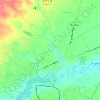
Name: North Hartsville topographic map, elevation, terrain.
Average elevation: 68 m
Minimum elevation: 43 m
Maximum elevation: 118 m
Other topographic maps
Click on a map to view its topography, its elevation and its terrain.
Society Hill
United States > South Carolina > Darlington County
Society Hill, Darlington County, South Carolina, United States
Average elevation: 32 m
Syracuse
United States > South Carolina > Darlington County
Syracuse, Darlington County, South Carolina, United States
Average elevation: 51 m
Hartsville
United States > South Carolina > Darlington County > Hartsville
Hartsville, Darlington County, South Carolina, 29550, United States
Average elevation: 67 m
Spring Acres
United States > South Carolina > Darlington County > Spring Acres
Spring Acres, Darlington County, South Carolina, 29532, United States
Average elevation: 46 m
Darlington
United States > South Carolina > Darlington County > Darlington
Darlington, Darlington County, South Carolina, 29532, United States
Average elevation: 46 m
Hartsville
United States > South Carolina > Darlington County
Hartsville, Darlington County, South Carolina, 29550, United States
Average elevation: 65 m