Geolocate

Skidaway Island topographic map

Click on the map to display elevation.

About this map

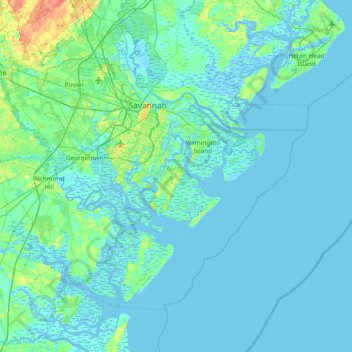
Name: Skidaway Island topographic map, elevation, terrain.

Location: Skidaway Island, Chatham County, Georgia, 31411, United States (31.62883 -81.35094 32.26883 -80.71094)

Average elevation: 3 m

Minimum elevation: -5 m

Maximum elevation: 28 m

Other topographic maps

Click on a map to view its topography, its elevation and its terrain.

Carl

United States > Georgia > Barrow County

Average elevation: 317 m

Winder

United States > Georgia > Barrow County > Winder

Average elevation: 274 m

Colquitt County

United States > Georgia

Average elevation: 85 m

St. Marys

United States > Georgia > Camden County

Average elevation: 3 m

Newton County

United States > Georgia

Average elevation: 217 m

Eatonton

United States > Georgia > Putnam County

Average elevation: 156 m

Gainesville

United States > Georgia > Hall County

Average elevation: 346 m

Conyers

United States > Georgia > Rockdale County

Average elevation: 251 m

Whitesburg

United States > Georgia > Carroll County

Average elevation: 249 m

Morgan County

United States > Georgia

Average elevation: 194 m

Metter

United States > Georgia > Candler County

Average elevation: 62 m

Cornelia

United States > Georgia > Habersham County

Average elevation: 446 m

Wheeler County

United States > Georgia

Average elevation: 62 m

Thompson Dam

United States > Georgia > Dooly County

Average elevation: 123 m

Elbert County

United States > Georgia

Average elevation: 177 m

Bryan County

United States > Georgia

Average elevation: 13 m

Valdosta

United States > Georgia > Lowndes County

Average elevation: 58 m

Orchard Hill

United States > Georgia > Spalding County

Average elevation: 253 m

Monroe County

United States > Georgia

Average elevation: 168 m

Atkinson County

United States > Georgia

Average elevation: 62 m

Villa Rica

United States > Georgia > Carroll County

Average elevation: 338 m

Shady Dale

United States > Georgia > Jasper County

Average elevation: 180 m

Gay

United States > Georgia > Meriwether County

Average elevation: 248 m

Douglasville

United States > Georgia > Douglas County

Located along a natural rise in the topography, Douglasville was originally known as "Skint Chestnut." The name was derived from a large tree used by Native Americans as a landmark; it was stripped of its bark so as to be more conspicuous.

Average elevation: 310 m

Senoia

United States > Georgia > Coweta County

Average elevation: 248 m

Hiram

United States > Georgia > Paulding County

Average elevation: 306 m

Berrien County

United States > Georgia

Average elevation: 74 m

Darien

United States > Georgia > McIntosh County

Average elevation: 3 m

Dodge County

United States > Georgia

The Heart of Georgia Regional Airport is located three miles east of Eastman off of State Route 46. Elevation 304'. Runway 02/20 is 6,506'x100'and has a precision instrument landing system. The airport is owned by the Heart of Georgia Regional Airport Authority and is home to the Middle Georgia State College…

Average elevation: 84 m

Pine Mountain

United States > Georgia > Harris County

Average elevation: 274 m

Norman Park

United States > Georgia > Colquitt County

Average elevation: 100 m

Turner County

United States > Georgia

Average elevation: 111 m

Greene County

United States > Georgia

Average elevation: 171 m

Decatur

United States > Georgia > DeKalb County

Average elevation: 308 m

Johns Creek

United States > Georgia > Johns Creek

Johns Creek is located in northeastern Fulton County and is centered at 34°1′44″N 84°11′55″W / 34.02889°N 84.19861°W / 34.02889; -84.19861 (34.0289259, -84.1985790). The elevation ranges from 880 feet (270 m) above sea level along the Chattahoochee River to 1,180 feet (360 m) in the Ocee…

Average elevation: 314 m

Stapleton

United States > Georgia > Jefferson County

Average elevation: 137 m

Camden County

United States > Georgia

Average elevation: 4 m

Dunwoody

United States > Georgia > DeKalb County > Dunwoody

Average elevation: 313 m

Waters Creek

United States > Georgia > Lumpkin County

Average elevation: 663 m

Harris County

United States > Georgia > Harris County

Average elevation: 204 m

Paulding County

United States > Georgia

The county is mainly located in the Piedmont region of the state, with a few mountains located in the county that exceed elevations of 1,000 ft. These mountains are considered to be part of the southernmost extensions of the Appalachian Mountains.

Average elevation: 311 m

Brooklet

United States > Georgia > Bulloch County

Average elevation: 49 m

Crisp County

United States > Georgia

Average elevation: 104 m

Clarkesville

United States > Georgia > Habersham County

Average elevation: 418 m