
Make a donation
Paulding County topographic map
Click on the map to display elevation.
Make a donation
Paulding County
The county is mainly located in the Piedmont region of the state, with a few mountains located in the county that exceed elevations of 1,000 ft. These mountains are considered to be part of the southernmost extensions of the Appalachian Mountains.
Make a donation
About this map
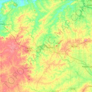
Name: Paulding County topographic map, elevation, terrain.
Location: Paulding County, Georgia, United States (33.77476 -85.05031 34.08261 -84.72324)
Average elevation: 311 m
Minimum elevation: 211 m
Maximum elevation: 452 m
Make a donation
Other topographic maps
Click on a map to view its topography, its elevation and its terrain.
Make a donation
Make a donation
Rivet Hill
United States > Georgia > Chattahoochee County > Chattahoochee County
Average elevation: 113 m
Make a donation
Atlanta
United States > Georgia > Fulton County
Atlanta (/ætˈlæntə/ at-LAN-tə) is the capital and most populous city of the U.S. state of Georgia. It is the seat of Fulton County, the most populous county in Georgia, but its territory falls in both Fulton and DeKalb counties. With a population of 498,715 living within the city limits, it is the eighth…
Average elevation: 285 m
Make a donation
Make a donation
Stadium Walk
United States > Georgia > Bulloch County > Statesboro > Stadium Walk
Average elevation: 63 m
Make a donation
Mount Vernon
United States > Georgia > Richmond County > Augusta > Mount Vernon
Average elevation: 77 m
Crestwood Estates
United States > Georgia > Athens-Clarke County > Athens-Clarke County Unified Government
Average elevation: 213 m
Make a donation