
Make a donation
Redwood Estates topographic map
Click on the map to display elevation.
Make a donation
About this map
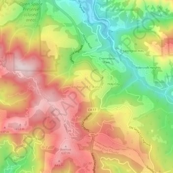
Name: Redwood Estates topographic map, elevation, terrain.
Average elevation: 447 m
Minimum elevation: 184 m
Maximum elevation: 687 m
Make a donation
Other topographic maps
Click on a map to view its topography, its elevation and its terrain.
Make a donation
Mount Madonna County Park
United States > California > Santa Clara County > Watsonville
Average elevation: 330 m
San Martin
United States > California > Santa Clara County > San Martin
Due to the moderating influence of the Pacific Ocean, San Martin enjoys a warm, Mediterranean climate. Temperatures range from an average midsummer maximum of 90.2°F (32.3°C) to an average midwinter low of 33.6 °F (0.9 °C). Average annual rainfall is 480 mm (18.9 in), and the summer months are typically…
Average elevation: 100 m
Make a donation
Almaden Quicksilver County Park
United States > California > Santa Clara County > San Jose
Almaden Quicksilver County Park is a 4,163 acres (17 km²) park that includes the grounds of former mercury ("quicksilver") mines adjacent to south San Jose, California, USA. The park's elevation varies greatly: the most used entrances (on the east side of the park) are less than 600 feet (183 m) above sea…
Average elevation: 267 m
Make a donation
Sierra Vista Open Space Preserve
United States > California > Santa Clara County > San Jose
Average elevation: 484 m
Fremont Older Open Space Preserve
United States > California > Santa Clara County
Average elevation: 212 m
Martial Cottle Park
United States > California > Santa Clara County > San Jose
Average elevation: 52 m
Make a donation
Santa Teresa County Park
United States > California > Santa Clara County > San Jose
Average elevation: 150 m
Los Gatos Creek County Park
United States > California > Santa Clara County > Campbell
Average elevation: 75 m
Make a donation