
Make a donation
Uvas Reservoir topographic map
Click on the map to display elevation.
Make a donation
About this map
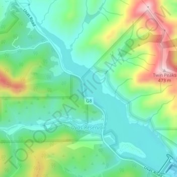
Name: Uvas Reservoir topographic map, elevation, terrain.
Average elevation: 224 m
Minimum elevation: 121 m
Maximum elevation: 455 m
Make a donation
Other topographic maps
Click on a map to view its topography, its elevation and its terrain.
Gilroy
United States > California > Santa Clara County > Gilroy
Gilroy is approximately 16 miles (26 km) south of San Jose, California (Bailey Avenue (37.206770, -121.729150) to Monterey/Day Road (37.038210, -121.584480)) on U.S. Route 101 and 19 miles (31 km) inland from the Pacific Coast. Despite its apparent close proximity to San Jose, it is important to note that…
Average elevation: 218 m
Morgan Hill
United States > California > Santa Clara County > Morgan Hill
Morgan Hill is approximately 39 km (24 mi) south of downtown San Jose, 21 km (13 mi) north of Gilroy, and 24 km (15 mi) inland from the Pacific coast. Lying in a roughly 6 km-wide (4-mi-wide) southern extension of the Santa Clara Valley, it is bounded by the Santa Cruz Mountains to the west and the Diablo…
Average elevation: 145 m
Katzman Automated Imaging Telescope
United States > California > Santa Clara County
Average elevation: 1,039 m
Make a donation
Make a donation
Creekside Village
United States > California > Santa Clara County > Los Gatos
Average elevation: 166 m
Pacheco Pass
United States > California > Santa Clara County
Pacheco Pass, elevation 1,368 ft (417 m), is a low mountain pass located in the Diablo Range in southeastern Santa Clara County, California. It is the main route through the hills separating the Santa Clara Valley and the Central Valley.
Average elevation: 425 m
Make a donation
Los Altos
United States > California > Santa Clara County > Los Altos > Los Altos
Average elevation: 82 m
Make a donation
Chemeketa Park
United States > California > Santa Clara County > Redwood Estates
Average elevation: 413 m
Make a donation
Sierra Vista Open Space Preserve
United States > California > Santa Clara County > San Jose
Average elevation: 484 m
Martial Cottle Park
United States > California > Santa Clara County > San Jose
Average elevation: 52 m
Los Gatos Creek County Park
United States > California > Santa Clara County > Campbell
Average elevation: 75 m
Make a donation
Lexington Hills
United States > California > Santa Clara County > Redwood Estates > Lexington Hills
Average elevation: 406 m
Make a donation
Aldercroft Heights
United States > California > Santa Clara County > Aldercroft Heights
Average elevation: 427 m
Vasona Junction
United States > California > Santa Clara County > Los Gatos > Vasona Junction
Average elevation: 89 m
Make a donation