
Thank you for supporting this site ❤️
Make a donation
Make a donation
Chirangara topographic map
Click on the map to display elevation.
Thank you for supporting this site ❤️
Make a donation
Make a donation
About this map
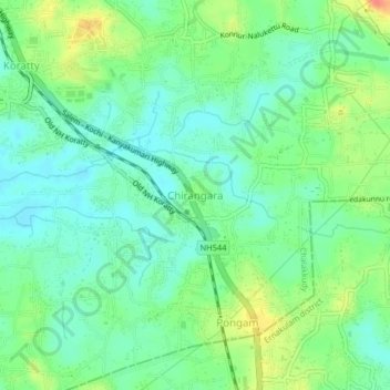
Name: Chirangara topographic map, elevation, terrain.
Location: Chirangara, Chalakkudy, Thrissur, Kerala, 680308, India (10.23545 76.34676 10.27545 76.38676)
Average elevation: 20 m
Minimum elevation: 1 m
Maximum elevation: 56 m
Thank you for supporting this site ❤️
Make a donation
Make a donation
Other topographic maps
Click on a map to view its topography, its elevation and its terrain.