
Thank you for supporting this site ❤️
Make a donation
Make a donation
Sholayar Dam topographic map
Click on the map to display elevation.
Thank you for supporting this site ❤️
Make a donation
Make a donation
About this map
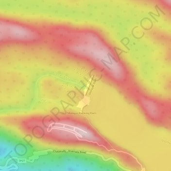
Name: Sholayar Dam topographic map, elevation, terrain.
Location: Sholayar Dam, Chalakkudy, Thrissur district, Kerala, India (10.32024 76.73483 10.32340 76.73613)
Average elevation: 800 m
Minimum elevation: 567 m
Maximum elevation: 930 m
Thank you for supporting this site ❤️
Make a donation
Make a donation
Other topographic maps
Click on a map to view its topography, its elevation and its terrain.
Thank you for supporting this site ❤️
Make a donation
Make a donation
Thank you for supporting this site ❤️
Make a donation
Make a donation