
Make a donation
Apostle Islands topographic map
Click on the map to display elevation.
Make a donation
About this map
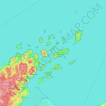
Name: Apostle Islands topographic map, elevation, terrain.
Location: Apostle Islands, Wisconsin, United States (46.61827 -90.97296 47.25827 -90.33296)
Average elevation: 197 m
Minimum elevation: 175 m
Maximum elevation: 431 m
Make a donation
Other topographic maps
Click on a map to view its topography, its elevation and its terrain.
Madison
United States > Wisconsin > Dane County
The city is sometimes described as The City of Four Lakes, comprising the four successive lakes of the Yahara River: Lake Mendota ("Fourth Lake"), Lake Monona ("Third Lake"), Lake Waubesa ("Second Lake") and Lake Kegonsa ("First Lake"), although Waubesa and Kegonsa are not actually in Madison, but just south…
Average elevation: 284 m
Milwaukee
United States > Wisconsin > Milwaukee County
Milwaukee County is characterized by a gently rolling landscape that transitions into flatter terrain as it approaches Lake Michigan. The region's elevation varies modestly, with most areas ranging from about 600 to 700 feet above sea level. The county features several prominent water bodies, including the…
Average elevation: 205 m
Make a donation
Dane County
Dane County showcases a diverse topography characterized by its rolling hills and numerous lakes, primarily shaped by glacial activity during the last Ice Age. The terrain varies significantly, with elevations ranging from approximately 860 feet to 1,200 feet above sea level. The county is famously known for…
Average elevation: 289 m
La Crosse
United States > Wisconsin > La Crosse County
Surrounding the relatively flat prairie valley where La Crosse lies are towering 500-foot (150 m) bluffs, one of the most prominent of which is Grandad Bluff (mentioned in Life on the Mississippi by Mark Twain), which has an overlook of the three states region. This feature typifies the topography of the…
Average elevation: 238 m
Make a donation
Door County
The 102-foot-high (31 m) Brussels Hill (44°45′06″N 87°35′27″W / 44.75166°N 87.59093°W / 44.75166; -87.59093 (Brussels Hill), elevation 851 feet [259 m]) is the highest point in the county. The nearby Red Hill Woods is the largest remaining maple–beech forest in the area.
Average elevation: 202 m
Make a donation
Madison
United States > Wisconsin > Dane County
The city is sometimes described as The City of Four Lakes, comprising the four successive lakes of the Yahara River: Lake Mendota ("Fourth Lake"), Lake Monona ("Third Lake"), Lake Waubesa ("Second Lake") and Lake Kegonsa ("First Lake"), although Waubesa and Kegonsa are not actually in Madison, but just south…
Average elevation: 284 m
Devil's Lake State Park
United States > Wisconsin > Sauk County > Town of Baraboo
Average elevation: 335 m
Make a donation
Wausau
United States > Wisconsin > Marathon County
According to the United States Census Bureau, the city has a total area of 20.33 square miles (52.7 km2), of which 19.22 square miles (49.8 km2) is land and 1.11 square miles (2.9 km2) is water. The city is located at an altitude of 1,195 feet (364 m). Wausau is close to the center of the northern half of the…
Average elevation: 394 m
Make a donation
Make a donation
Make a donation
Make a donation
West Bend
United States > Wisconsin > Washington County
West Bend is in the Kettle Moraine region, and its topography is varied. The glacial activity has formed many kettles and hills throughout the region.
Average elevation: 298 m
Make a donation
Make a donation
Make a donation
Make a donation
Janesville
United States > Wisconsin > Rock County
According to the United States Census Bureau, the city has a total area of 34.76 square miles (90.03 km2), of which 34.16 square miles (88.47 km2) is land and 0.6 square miles (1.55 km2) is water. The city is divided by the Rock River. Elevation is 837 ft, or 255 m.
Average elevation: 264 m
Make a donation
Make a donation
Make a donation
Make a donation
Parfrey's Glen State Natural Area
United States > Wisconsin > Sauk County > Town of Merrimac
Average elevation: 360 m
Make a donation
Make a donation
Apostle Islands
United States > Wisconsin > Ashland County > Town of La Pointe
Average elevation: 188 m
Make a donation
Make a donation
Make a donation
Make a donation
Make a donation
Make a donation
Make a donation