
Make a donation
Dane County topographic map
Click on the map to display elevation.
Make a donation
Dane County
Dane County showcases a diverse topography characterized by its rolling hills and numerous lakes, primarily shaped by glacial activity during the last Ice Age. The terrain varies significantly, with elevations ranging from approximately 860 feet to 1,200 feet above sea level. The county is famously known for the Yahara River chain of lakes, which includes Lakes Mendota, Monona, Waubesa, and Kegonsa, forming an "isthmus" in Madison. This river system, combined with the surrounding hills, creates a picturesque landscape that is both scenic and ecologically rich. In addition to the lakes, the county features numerous parks and natural areas that highlight its topographical variety, including woodlands and prairies, contributing to the region's biodiversity and recreational opportunities.
Make a donation
About this map
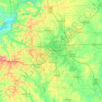
Name: Dane County topographic map, elevation, terrain.
Location: Dane County, Wisconsin, United States (42.84515 -89.83857 43.29416 -89.00883)
Average elevation: 289 m
Minimum elevation: 218 m
Maximum elevation: 477 m
Make a donation
Other topographic maps
Click on a map to view its topography, its elevation and its terrain.
Milwaukee River Floodplain Forest State Natural Area
United States > Wisconsin > Washington County
Average elevation: 291 m
Parfrey's Glen State Natural Area
United States > Wisconsin > Sauk County > Town of Merrimac
Average elevation: 360 m
Make a donation
Make a donation
Observatory Hill State Natural Area
United States > Wisconsin > Marquette County
Average elevation: 262 m
Make a donation
Make a donation
Make a donation
Make a donation
Wildcat Mountain State Park
United States > Wisconsin > Vernon County > Town of Whitestown
Average elevation: 310 m
Make a donation
Make a donation
Make a donation
Englewood
United States > Wisconsin > Columbia County > Town of Fountain Prairie
Average elevation: 276 m
Make a donation
Make a donation
Make a donation
Fox Lake Junction
United States > Wisconsin > Dodge County > Town of Fox Lake
Average elevation: 272 m
Make a donation
Make a donation
Wilderness Lake
United States > Wisconsin > Bayfield County > Town of Drummond
Average elevation: 391 m
McAllister
United States > Wisconsin > Marinette County
McAllister is located at the intersection of Wisconsin Highway 180 and County Highway JJ 11.5 miles (18.5 km) east-southeast of Wausaukee at an elevation of 692 feet (211 m). It is connected by road to Wausaukee to the west, Packard to the north, Wagner to the south, and Wallace, Michigan, to the east via a…
Average elevation: 210 m
Make a donation
Sheboygan Marsh 2 WP 319 Dam
United States > Wisconsin > Sheboygan County > Town of Russell
Average elevation: 284 m
Governor Dodge State Park
United States > Wisconsin > Iowa County > Town of Dodgeville
Average elevation: 336 m
Make a donation
Wildcat Mountain State Park
United States > Wisconsin > Vernon County > Town of Whitestown
Average elevation: 310 m
Graham Corners
United States > Wisconsin > Fond du Lac County > Town of Forest
Average elevation: 323 m
Make a donation
Northern Wisconsin State Fairgrounds
United States > Wisconsin > Chippewa County > Chippewa Falls
Average elevation: 279 m
Make a donation
Make a donation
Walking Iron County Park
United States > Wisconsin > Dane County > Town of Mazomanie
Average elevation: 236 m
Deansville Wildlife Area
United States > Wisconsin > Dane County > Town of York
Average elevation: 264 m
Make a donation
Long Slide Falls County Park
United States > Wisconsin > Marinette County > Town of Niagra
Average elevation: 288 m
Make a donation
Aztalan State Park
United States > Wisconsin > Jefferson County > Town of Aztalan
Average elevation: 255 m
Make a donation
George W Mead State Wildlife Management Area
United States > Wisconsin > Marathon County > Town of Bergen
Average elevation: 343 m
Liberty Creek State Wildlife Area
United States > Wisconsin > Green County > Town of Albany
Average elevation: 263 m
Make a donation
Danbury
United States > Wisconsin > Burnett County > Town of Swiss
Danbury is located at 46.006N. The longitude is -92.371W. It is in the Central Standard Time Zone. The elevation is 938 feet (286 m) above sea level.
Average elevation: 287 m
Beartrap Lake
United States > Wisconsin > Washburn County > Town of Birchwood
Average elevation: 431 m
Moose Junction
United States > Wisconsin > Douglas County > Town of Dairyland
Average elevation: 372 m
Make a donation
Make a donation