
Make a donation
Devils Staircase topographic map
Click on the map to display elevation.
Make a donation
About this map
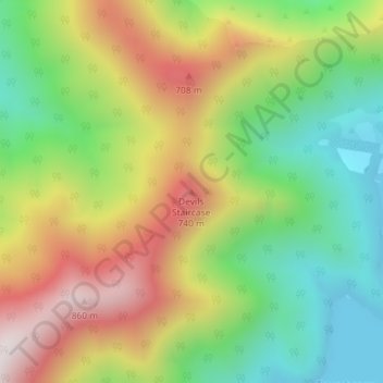
Name: Devils Staircase topographic map, elevation, terrain.
Location: Devils Staircase, Marlborough, New Zealand (-41.08227 173.85014 -41.08217 173.85024)
Average elevation: 372 m
Minimum elevation: 0 m
Maximum elevation: 852 m
Make a donation
Other topographic maps
Click on a map to view its topography, its elevation and its terrain.
Mount Richmond Forest Park
Established in 1977, the forest park is located between Nelson and Marlborough and consists of 1,659 km2 (641 sq mi) of conservation estate. Around 80% of the area is covered in bush. The most notable peak in the forest park is Mount Richmond, which has an elevation above sea level of 1,760 metres (5,770 ft).
Average elevation: 403 m
Make a donation
Make a donation
Saint Arnaud Range
New Zealand > Marlborough > Marlborough District
The lower elevations are covered primarily in beech forests, while higher elevations (above about 5,000 feet) are alpine.
Average elevation: 1,249 m
Make a donation
Make a donation
Saint Arnaud Range
New Zealand > Marlborough > Marlborough District
The lower elevations are covered primarily in beech forests, while higher elevations (above about 5,000 feet) are alpine.
Average elevation: 1,249 m
Make a donation
Make a donation