
Make a donation
Gaza Strip topographic map
Click on the map to display elevation.
Make a donation
Gaza Strip
The topography of the Gaza Strip is dominated by three ridges parallel to the coastline, which consist of Pleistocene-Holocene aged calcareous aeolian (wind deposited) sandstones, locally referred to as "kurkar", intercalated with red-coloured fine grained paleosols, referred to as "hamra". The three ridges are separated by wadis, which are filled with alluvial deposits. The terrain is flat or rolling, with dunes near the coast. The highest point is Abu 'Awdah (Joz Abu 'Auda), at 105 m (344 ft) above sea level.
Make a donation
About this map
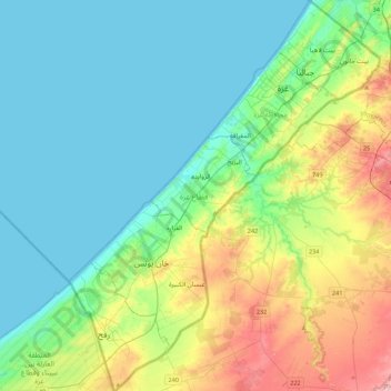
Name: Gaza Strip topographic map, elevation, terrain.
Location: Gaza Strip, Palestinian Territories (31.22013 34.21590 31.59685 34.56732)
Average elevation: 44 m
Minimum elevation: 0 m
Maximum elevation: 170 m
Make a donation
Other topographic maps
Click on a map to view its topography, its elevation and its terrain.
Efrat
Palestinian Territories > Judea and Samaria > Area C
Efrat (Hebrew: אֶפְרָת), or previously officially Efrata (Hebrew: אֶפְרָתָה), is an Israeli settlement in the West Bank, established in 1983 in the Judean Mountains. Efrat is located 12 kilometers (7.5 mi) south of Jerusalem, between Bethlehem and Hebron, 6.5 km (4 mi) east of the Green Line,…
Average elevation: 898 m