
Thank you for supporting this site ❤️
Make a donation
Make a donation
Silver Creek topographic map
Click on the map to display elevation.
Thank you for supporting this site ❤️
Make a donation
Make a donation
About this map
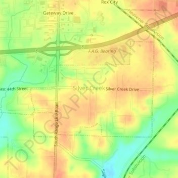
Name: Silver Creek topographic map, elevation, terrain.
Location: Silver Creek, Newton County, Missouri, United States (37.03315 -94.47913 37.04765 -94.46038)
Average elevation: 315 m
Minimum elevation: 288 m
Maximum elevation: 331 m
Thank you for supporting this site ❤️
Make a donation
Make a donation
Other topographic maps
Click on a map to view its topography, its elevation and its terrain.
Shoal Creek
United States > Missouri > Newton County > Joplin > Cliff Village
Average elevation: 295 m
Thank you for supporting this site ❤️
Make a donation
Make a donation