
Thank you for supporting this site ❤️
Make a donation
Make a donation
Gardner Peak topographic map
Click on the map to display elevation.
Thank you for supporting this site ❤️
Make a donation
Make a donation
About this map
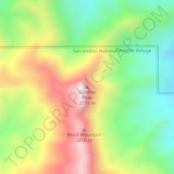
Name: Gardner Peak topographic map, elevation, terrain.
Location: Gardner Peak, Doña Ana County, New Mexico, United States (32.82392 -106.56144 32.82402 -106.56134)
Average elevation: 1,868 m
Minimum elevation: 1,541 m
Maximum elevation: 2,289 m
Thank you for supporting this site ❤️
Make a donation
Make a donation
Other topographic maps
Click on a map to view its topography, its elevation and its terrain.
Organ Mountains-Desert Peaks National Monument
United States > New Mexico > Doña Ana County
Average elevation: 1,335 m
Thank you for supporting this site ❤️
Make a donation
Make a donation