
Thank you for supporting this site ❤️
Make a donation
Make a donation
Assyria Township topographic map
Click on the map to display elevation.
Thank you for supporting this site ❤️
Make a donation
Make a donation
About this map
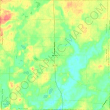
Name: Assyria Township topographic map, elevation, terrain.
Location: Assyria Township, Barry County, Michigan, United States (42.42065 -85.19063 42.50913 -85.07152)
Average elevation: 276 m
Minimum elevation: 252 m
Maximum elevation: 309 m
Thank you for supporting this site ❤️
Make a donation
Make a donation
Other topographic maps
Click on a map to view its topography, its elevation and its terrain.
Yankee Springs Recreation Area
United States > Michigan > Barry County > Middleville
Average elevation: 246 m
Thank you for supporting this site ❤️
Make a donation
Make a donation