
Thank you for supporting this site ❤️
Make a donation
Make a donation
Dowling topographic map
Click on the map to display elevation.
Thank you for supporting this site ❤️
Make a donation
Make a donation
About this map
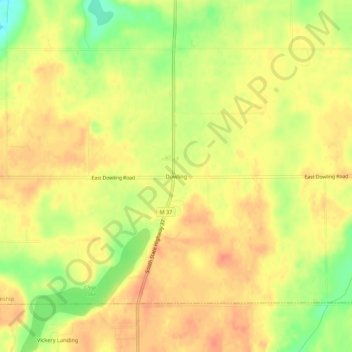
Name: Dowling topographic map, elevation, terrain.
Average elevation: 292 m
Minimum elevation: 261 m
Maximum elevation: 308 m
Thank you for supporting this site ❤️
Make a donation
Make a donation
Other topographic maps
Click on a map to view its topography, its elevation and its terrain.
Thank you for supporting this site ❤️
Make a donation
Make a donation
Yankee Springs Recreation Area
United States > Michigan > Barry County > Middleville
Average elevation: 246 m