
Umbria topographic map
Interactive map
Click on the map to display elevation.
Umbria
Umbria is bordered by Tuscany to the west and the north, Marche to the east and Lazio to the south. Partly hilly and mountainous, and partly flat and fertile owing to the valley of the Tiber, its topography includes part of the central Apennines, with the highest point in the region at Monte Vettore on the border of Marche, at 2,476 metres (8,123 feet); the lowest point is Attigliano, 96 metres (315 feet). It is the only Italian region having neither a coastline nor a common border with other countries. The comune of Città di Castello has an exclave named Monte Ruperto within Marche. Contained within Umbria is the hamlet of Cospaia, which was a tiny republic from 1440 to 1826, created by accident.
About this map
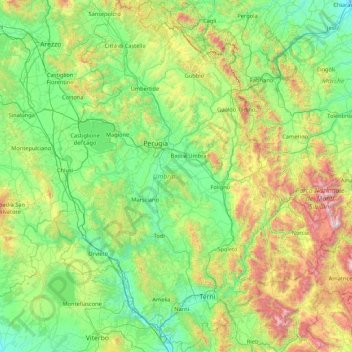
Name: Umbria topographic map, elevation, terrain.
Location: Umbria, Italy (42.36478 11.89203 43.61734 13.26419)
Average elevation: 521 m
Minimum elevation: 15 m
Maximum elevation: 2,445 m
Other topographic maps
Click on a map to view its topography, its elevation and its terrain.
Welsberg - Monguelfo
Italy > Trentino – Alto Adige/Südtirol > South Tyrol > Welsberg-Taisten - Monguelfo-Tesido
Average elevation: 1,289 m
Monte Pizzoc
Italy > Veneto > Province of Treviso > Fregona
Pizzoc is a mountain of the Veneto, Italy. It has an elevation of 1,565 metres.
Average elevation: 1,240 m
Costadedoi
Italy > Trentino – Alto Adige/Südtirol > South Tyrol > San Ćiascian - St. Kassian - San Cassiano
Average elevation: 1,712 m
Cortina
Italy > Trentino – Alto Adige/Südtirol > Provincia di Trento > Vermiglio
Average elevation: 1,540 m
Populonia
Italy > Tuscany > Livorno > Piombino
In geology, the "Tuscan metallogenic province" derived from volcanic intrusions into southern Etruria due to extension of the crust there (which also created a karst topography in western Italy) from the late Miocene to the Pleistocene. This process emplaced iron oxide deposits on Elba, pyrite in southern…
Average elevation: 34 m
Maring
Italy > Trentino – Alto Adige/Südtirol > South Tyrol > La Ila - Stern - La Villa
Average elevation: 1,727 m
Villa Nöia
Italy > Trentino – Alto Adige/Südtirol > South Tyrol > La Ila - Stern - La Villa
Average elevation: 1,632 m
Matterhorn
Italy > Aosta Valley > Valtournenche
In 1999, the summit height was precisely determined to be at 4,477.54 m (14,690 ft) above sea level by using Global Positioning System technology as part of the TOWER Project (Top of the World Elevations Remeasurement) and to an accuracy of less than one centimetre, which allows future changes to be tracked.
Average elevation: 3,295 m
Roen
Italy > Trentino – Alto Adige/Südtirol > South Tyrol > Tramin an der Weinstraße - Termeno sulla Strada del Vino
Average elevation: 1,740 m
Funtanacia
Italy > Trentino – Alto Adige/Südtirol > South Tyrol > La Ila - Stern - La Villa
Average elevation: 1,787 m
Schneespitz - Cima della Neve
Italy > Trentino – Alto Adige/Südtirol > South Tyrol > Predoi
Average elevation: 2,497 m
Biacesa di Ledro
Italy > Trentino – Alto Adige/Südtirol > Provincia di Trento
Average elevation: 831 m
Mount Vesuvius
Italy > Campania > Naples > Trecase
The volcano's slopes are scarred by lava flows, while the rest are heavily vegetated, with scrub and forests at higher altitudes and vineyards lower down.
Average elevation: 862 m
Mount Etna
During the first 1500 years AD, many eruptions went unrecorded (or records have been lost); among the more significant are: (1) an eruption in about 1030 AD near Monte Ilice on the lower southeast flank, which produced a lava flow that travelled about 10 km, reaching the sea north of Acireale; the villages of…
Average elevation: 1,157 m
Matterhorn
Italy > Aosta Valley > Valtournenche
In 1999, the summit height was precisely determined to be at 4,477.54 m (14,690 ft) above sea level by using Global Positioning System technology as part of the TOWER Project (Top of the World Elevations Remeasurement) and to an accuracy of less than one centimetre, which allows future changes to be tracked.
Average elevation: 3,295 m
Salmagi
Italy > Sardinia > Casteddu/Cagliari > Quartu Sant'Aleni/Quartu Sant'Elena > Terra Mala
Average elevation: 60 m
Pinzon - Pinzano
Italy > Trentino – Alto Adige/Südtirol > South Tyrol > Montan an der Weinstraße - Montagna sulla Strada del Vino
Average elevation: 524 m
Valsorda
Italy > Trentino – Alto Adige/Südtirol > Provincia di Trento > Predazzo
Average elevation: 1,785 m
Ghiacciaio di Indren
Italy > Aosta Valley > Vercelli > Gressoney-La-Trinité
Average elevation: 3,480 m
Grube - Fossa
Italy > Trentino – Alto Adige/Südtirol > South Tyrol > Oberradein - Redagno di Sopra
Average elevation: 1,477 m
Mount Vesuvius
Italy > Campania > Naples > Trecase
The volcano's slopes are scarred by lava flows, while the rest are heavily vegetated, with scrub and forests at higher altitudes and vineyards lower down.
Average elevation: 862 m