Northlake topographic map
Interactive map
Click on the map to display elevation.
About this map
![Northlake topographic map, elevation, terrain](/pub/maps/relation/3cgp/sc5z4/thumbnail.jpg)
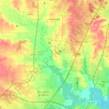
Name: Northlake topographic map, elevation, terrain.
Location: Northlake, Denton County, Texas, United States (33.01811 -97.29361 33.15054 -97.21648)
Average elevation: 203 m
Minimum elevation: 164 m
Maximum elevation: 244 m
Other topographic maps
Click on a map to view its topography, its elevation and its terrain.
![Denton topographic map, elevation, terrain](/pub/maps/relation/6ks8/7tdkl/icon.jpg)
Denton
United States > Texas > Denton County
Denton, Denton County, Texas, United States
Average elevation: 195 m
![Roanoke topographic map, elevation, terrain](/pub/maps/relation/3ctp/f2zs8/icon.jpg)
Roanoke
United States > Texas > Denton County
Roanoke, Denton County, Texas, 76262, United States
Average elevation: 186 m
![Providence Village topographic map, elevation, terrain](/pub/maps/node/wjtf/7tjvf94s/icon.jpg)
Providence Village
United States > Texas > Denton County
Providence Village, Denton County, Texas, 76227, United States
Average elevation: 178 m
![Krum topographic map, elevation, terrain](/pub/maps/relation/3zgp/scbz4/icon.jpg)
Krum
United States > Texas > Denton County
Krum, Denton County, Texas, United States
Average elevation: 219 m
![Lewisville Lake topographic map, elevation, terrain](/pub/maps/relation/3j1h/dkzf3/icon.jpg)
Lewisville Lake
United States > Texas > Denton County > Oak Point
Lewisville Lake, Oak Point, Denton County, Texas, 75068, United States
Average elevation: 169 m
![Lakewood Village topographic map, elevation, terrain](/pub/maps/relation/6bzs/x9frb3/icon.jpg)
Lakewood Village
United States > Texas > Denton County
Lakewood Village, Denton County, Texas, United States
Average elevation: 162 m
![Bartonville topographic map, elevation, terrain](/pub/maps/relation/w7nx/gwqfkl/icon.jpg)
Bartonville
United States > Texas > Denton County
Bartonville, Denton County, Texas, United States
Average elevation: 198 m
![Hickory Creek topographic map, elevation, terrain](/pub/maps/relation/6vzs/cr75k/icon.jpg)
Hickory Creek
United States > Texas > Denton County
Hickory Creek, Denton County, Texas, United States
Average elevation: 169 m
![Stony topographic map, elevation, terrain](/pub/maps/node/vn51/s6fxcmt/icon.jpg)
Stony
United States > Texas > Denton County
Stony, Denton County, Texas, United States
Average elevation: 240 m
![Double Oak topographic map, elevation, terrain](/pub/maps/relation/1cm2/m4l1rr/icon.jpg)
Double Oak
United States > Texas > Denton County
Double Oak, Denton County, Texas, United States
Average elevation: 197 m
![Plainview topographic map, elevation, terrain](/pub/maps/node/dw1h/694hn9m/icon.jpg)
Plainview
United States > Texas > Denton County
Plainview, Denton County, Texas, United States
Average elevation: 248 m
![Navo topographic map, elevation, terrain](/pub/maps/node/pvcz/h3vkdrr/icon.jpg)
Navo
United States > Texas > Denton County
Navo, Denton County, Texas, 75068, United States
Average elevation: 170 m
![Bolivar topographic map, elevation, terrain](/pub/maps/node/g7f3/sdvc2mt/icon.jpg)
Bolivar
United States > Texas > Denton County > Sanger
Bolivar, Sanger, Denton County, Texas, United States
Average elevation: 214 m
![Drop topographic map, elevation, terrain](/pub/maps/node/pltj/jrqhh5k/icon.jpg)
Drop
United States > Texas > Denton County
Drop, Denton County, Texas, United States
Average elevation: 223 m
![Mustang topographic map, elevation, terrain](/pub/maps/node/4cgt/bqfvrt6/icon.jpg)
Mustang
United States > Texas > Denton County
Mustang, Denton County, Texas, United States
Average elevation: 182 m
![Cross Roads topographic map, elevation, terrain](/pub/maps/relation/gtb3/flzvmt/icon.jpg)
Cross Roads
United States > Texas > Denton County
Cross Roads, Denton County, Texas, United States
Average elevation: 172 m
![Hackberry topographic map, elevation, terrain](/pub/maps/relation/mpz4/ls7pdn/icon.jpg)
Hackberry
United States > Texas > Denton County
Hackberry, Denton County, Texas, United States
Average elevation: 167 m
![Cooper Creek topographic map, elevation, terrain](/pub/maps/node/jnnx/l6t2ctp/icon.jpg)
Cooper Creek
United States > Texas > Denton County > Denton
Cooper Creek, Denton, Denton County, Texas, 76298, United States
Average elevation: 184 m
![Hebron topographic map, elevation, terrain](/pub/maps/relation/6cmt/wxtm4s/icon.jpg)
Hebron
United States > Texas > Denton County
Hebron, Denton County, Texas, United States
Average elevation: 191 m
![Mingo topographic map, elevation, terrain](/pub/maps/node/dnkl/9g3gd4s/icon.jpg)
Mingo
United States > Texas > Denton County > Denton
Mingo, Denton, Denton County, Texas, 76298, United States
Average elevation: 172 m
![Paloma Creek South HOA Playground topographic map, elevation, terrain](/pub/maps/way/gw3l/t9f51tp/icon.jpg)
Paloma Creek South HOA Playground
United States > Texas > Denton County > Navo
Paloma Creek South HOA Playground, Navo, Denton County, Texas, United States
Average elevation: 170 m
![Green Valley topographic map, elevation, terrain](/pub/maps/node/7z3l/9bkt3zs/icon.jpg)
Green Valley
United States > Texas > Denton County > Denton
Green Valley, Denton, Denton County, Texas, United States
Average elevation: 180 m
![Draper topographic map, elevation, terrain](/pub/maps/relation/4nnh/j5r7t6/icon.jpg)
Draper
United States > Texas > Denton County
Draper, Denton County, Texas, United States
Average elevation: 213 m
![Krugerville topographic map, elevation, terrain](/pub/maps/relation/1k3q/mjxgt/icon.jpg)
Krugerville
United States > Texas > Denton County
Krugerville, Denton County, Texas, United States
Average elevation: 204 m
![North Pointe Park topographic map, elevation, terrain](/pub/maps/way/82tp/qtdm7tf/icon.jpg)
North Pointe Park
United States > Texas > Denton County > Denton
North Pointe Park, Denton, Denton County, Texas, 76201, United States
Average elevation: 210 m
![Fort Worth topographic map, elevation, terrain](/pub/maps/way/sw14/dvfdmtf/icon.jpg)
Fort Worth
United States > Texas > Denton County
Fort Worth, Denton County, Texas, United States
Average elevation: 213 m
![Little Elm topographic map, elevation, terrain](/pub/maps/relation/87gp/rcbmnx/icon.jpg)
Little Elm
United States > Texas > Denton County
Little Elm, Denton County, Texas, 75068, United States
Average elevation: 171 m
![Flower Mound topographic map, elevation, terrain](/pub/maps/relation/h33q/xdvvzs/icon.jpg)
Flower Mound
United States > Texas > Denton County
Flower Mound, Denton County, Texas, United States
Average elevation: 178 m
![Nix Slough topographic map, elevation, terrain](/pub/maps/node/6jgt/ndspst6/icon.jpg)
Nix Slough
United States > Texas > Denton County
Nix Slough, Denton County, Texas, 75068, United States
Average elevation: 165 m
![Oak Point topographic map, elevation, terrain](/pub/maps/relation/s8b3/flk4mt/icon.jpg)
Oak Point
United States > Texas > Denton County
Oak Point, Denton County, Texas, United States
Average elevation: 171 m
![Pilot Point topographic map, elevation, terrain](/pub/maps/relation/pngt/tnmctj/icon.jpg)
Pilot Point
United States > Texas > Denton County
Pilot Point, Denton County, Texas, 76258, United States
Average elevation: 198 m
![Sanger topographic map, elevation, terrain](/pub/maps/relation/rzcz/38dt51/icon.jpg)
Sanger
United States > Texas > Denton County
Sanger, Denton County, Texas, 76266, United States
Average elevation: 209 m
![Trophy Club topographic map, elevation, terrain](/pub/maps/relation/zjtj/hp31cz/icon.jpg)
Trophy Club
United States > Texas > Denton County
Trophy Club, Denton County, Texas, United States
Average elevation: 187 m
![Corinth topographic map, elevation, terrain](/pub/maps/relation/s9z4/dfm5gp/icon.jpg)
Corinth
United States > Texas > Denton County
Corinth, Denton County, Texas, 76210, United States
Average elevation: 180 m
![Ponder topographic map, elevation, terrain](/pub/maps/relation/7dt6/k7gs9m/icon.jpg)
Ponder
United States > Texas > Denton County
Ponder, Denton County, Texas, 76259, United States
Average elevation: 225 m
![Sanger topographic map, elevation, terrain](/pub/maps/node/k857/9bc8qzs/icon.jpg)
Sanger
United States > Texas > Denton County > Sanger > Sanger
Sanger, Denton County, Texas, 76266, United States
Average elevation: 205 m
![The Colony topographic map, elevation, terrain](/pub/maps/relation/s21h/7n23l/icon.jpg)
The Colony
United States > Texas > Denton County
The Colony, Denton County, Texas, 75056, United States
Average elevation: 175 m
![Westlake topographic map, elevation, terrain](/pub/maps/relation/3rtp/f2cs8/icon.jpg)
Westlake
United States > Texas > Denton County
Westlake, Denton County, Texas, United States
Average elevation: 199 m
![Justin topographic map, elevation, terrain](/pub/maps/relation/mp14/wxjfzs/icon.jpg)
Justin
United States > Texas > Denton County
Justin, Denton County, Texas, United States
Average elevation: 198 m
![Shady Shores topographic map, elevation, terrain](/pub/maps/relation/fw18/j59tt6/icon.jpg)
Shady Shores
United States > Texas > Denton County
Shady Shores, Denton County, Texas, United States
Average elevation: 165 m
![Argyle topographic map, elevation, terrain](/pub/maps/relation/5zt6/5k1qnx/icon.jpg)
Argyle
United States > Texas > Denton County
Argyle, Denton County, Texas, United States
Average elevation: 206 m
![Lewisville topographic map, elevation, terrain](/pub/maps/node/56kl/7w1x118/icon.jpg)
Lewisville
United States > Texas > Denton County > Lewisville
Lewisville, Denton County, Texas, 75067, United States
Average elevation: 174 m
![South Lakes Park topographic map, elevation, terrain](/pub/maps/way/995k/3zr6fz4/icon.jpg)
South Lakes Park
United States > Texas > Denton County > Denton
South Lakes Park, Denton, Denton County, Texas, 76205, United States
Average elevation: 201 m
![DISH topographic map, elevation, terrain](/pub/maps/relation/pvmt/wxjl4s/icon.jpg)
DISH
United States > Texas > Denton County
DISH, Denton County, Texas, United States
Average elevation: 201 m
![Highland Village topographic map, elevation, terrain](/pub/maps/relation/gqzs/fmqqgp/icon.jpg)
Highland Village
United States > Texas > Denton County
Highland Village, Denton County, Texas, 75077, United States
Average elevation: 170 m
![Copper Canyon topographic map, elevation, terrain](/pub/maps/relation/163q/mjkgt/icon.jpg)
Copper Canyon
United States > Texas > Denton County
Copper Canyon, Denton County, Texas, United States
Average elevation: 184 m
![Lewisville topographic map, elevation, terrain](/pub/maps/relation/89tp/k9rz4/icon.jpg)
Lewisville
United States > Texas > Denton County
Lewisville, Denton County, Texas, United States
Average elevation: 160 m
![Parvin topographic map, elevation, terrain](/pub/maps/node/vfcz/5cm6657/icon.jpg)
Parvin
United States > Texas > Denton County > Prosper
Parvin, Prosper, Denton County, Texas, United States
Average elevation: 180 m
![Aubrey topographic map, elevation, terrain](/pub/maps/relation/2dtj/d15b3/icon.jpg)
Aubrey
United States > Texas > Denton County
Aubrey, Denton County, Texas, United States
Average elevation: 197 m