
吉林省 topographic map
Interactive map
Click on the map to display elevation.
About this map
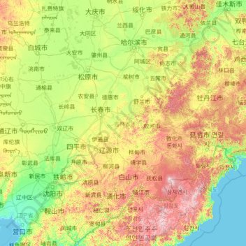
Name: 吉林省 topographic map, elevation, terrain.
Location: 吉林省, 中国 (40.86183 121.63571 46.30298 131.31137)
Average elevation: 353 m
Minimum elevation: -1 m
Maximum elevation: 2,529 m
总体趋势为东南高、西北低。以北东-南西向纵贯全省的大黑山山脉为界,分为东部长白山地和西部松辽平原两大区域,面积分别占全省的60%和40%。省内最高点为长白山白云峰,海拔2691m,也是东北地区最高峰。低平原区海拔多在120m以上。省内最低点位于珲春市敬信镇防川村图们江下游中、朝、俄三国交界处,海拔仅为5.0m。
Other topographic maps
Click on a map to view its topography, its elevation and its terrain.