
西藏自治区 topographic map
Interactive map
Click on the map to display elevation.
About this map
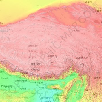
Name: 西藏自治区 topographic map, elevation, terrain.
Location: 西藏自治区, 中国 (27.21205 78.39232 36.48407 99.11555)
Average elevation: 3,040 m
Minimum elevation: -1 m
Maximum elevation: 8,096 m
西藏东面和北面与中华人民共和国青海省、四川省、云南省和新疆维吾尔自治区相邻,西面和南面与缅甸、印度、不丹、尼泊尔等国相邻。西藏为青藏高原的一部份;青藏高原,面积250万平方公里,占中国总面积的八分之一,平均高度在海拔4000公尺以上,是全球最高最大的高原,素有“世界屋脊”之称。距今两亿年前,本区原为一片汪洋大海,两千多万年前始在古喜马拉雅山造山运动中大幅崛起,形成今日的高原地貌。
Other topographic maps
Click on a map to view its topography, its elevation and its terrain.