
Thank you for supporting this site ❤️
Make a donation
Make a donation
Livingstone Range topographic map
Click on the map to display elevation.
Thank you for supporting this site ❤️
Make a donation
Make a donation
About this map
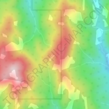
Name: Livingstone Range topographic map, elevation, terrain.
Average elevation: 1,825 m
Minimum elevation: 1,629 m
Maximum elevation: 2,054 m
Thank you for supporting this site ❤️
Make a donation
Make a donation
Other topographic maps
Click on a map to view its topography, its elevation and its terrain.
Beehive Natural Area
Canada > Alberta > Municipal District of Ranchland No. 66 > Area A (Upper Flathead/Elk Valley)
Average elevation: 2,102 m