
Make a donation
Deer Creek topographic map
Click on the map to display elevation.
Make a donation
About this map
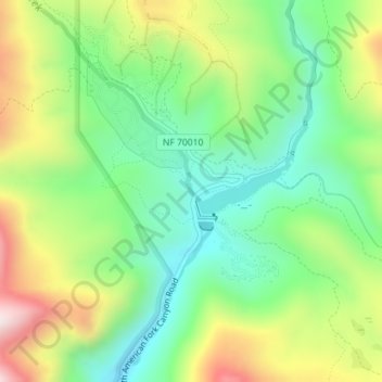
Name: Deer Creek topographic map, elevation, terrain.
Location: Deer Creek, Utah County, Utah, United States (40.48272 -111.64763 40.48280 -111.64760)
Average elevation: 2,131 m
Minimum elevation: 1,903 m
Maximum elevation: 2,507 m
Make a donation
Other topographic maps
Click on a map to view its topography, its elevation and its terrain.
Utah Lake
United States > Utah > Utah County
Utah Lake is a shallow freshwater lake in the center of Utah County, Utah, United States. It lies in Utah Valley, surrounded by the Provo-Orem metropolitan area. The lake's only river outlet, the Jordan River, is a tributary of the Great Salt Lake. Evaporation accounts for 42% of the lake's outflow, which…
Average elevation: 1,512 m
Make a donation
Make a donation
Lone Peak Wilderness
United States > Utah > Utah County > Alpine
The Lone Peak Wilderness provides a spectacular backdrop for the growing urban areas along the Wasatch Front and is dominated by rugged terrain, narrow canyons and high peaks, including the Pfeifferhorn, commonly referred to as Little Matterhorn Peak, at 11,326 feet (3,452 m) and Lone Peak at 11,253 feet…
Average elevation: 2,367 m
Make a donation