
拉萨市 topographic map
Interactive map
Click on the map to display elevation.
About this map
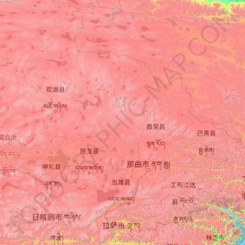
Name: 拉萨市 topographic map, elevation, terrain.
Location: 拉萨市, 西藏自治区, 850000, 中国 (29.24065 89.75281 36.34330 95.16436)
Average elevation: 4,866 m
Minimum elevation: 2,877 m
Maximum elevation: 7,466 m
拉萨(藏文:ལྷ་ས་,威利转写:lha-sa,藏语拼音:Lhasa;國際音標:/l̥ásə/ 或 /l̥ɜ́ːsə/),唐代譯作逻些、邏逤、邏娑、惹萨,为中華人民共和國西藏自治区首府。拉萨城区海拔3,663.5米,拉萨河流经此,在南郊注入雅鲁藏布江。
Other topographic maps
Click on a map to view its topography, its elevation and its terrain.