
Kenya topographic map
Interactive map
Click on the map to display elevation.
About this map
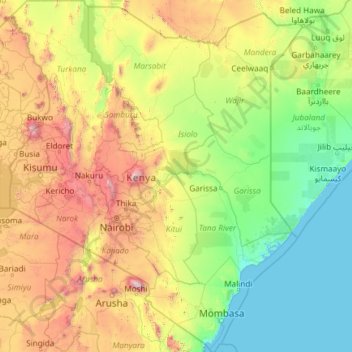
Name: Kenya topographic map, elevation, terrain.
Location: Kenya (-4.89952 33.90969 4.62000 41.90675)
Average elevation: 717 m
Minimum elevation: 0 m
Maximum elevation: 5,698 m
Kenya's climate varies from tropical along the coast to temperate inland to arid in the north and northeast parts of the country. The area receives a great deal of sunshine every month. It is usually cool at night and early in the morning inland at higher elevations.
Other topographic maps
Click on a map to view its topography, its elevation and its terrain.
Lake Turkana
Lake Turkana, Marsabit County, East Kenya, Kenya
Average elevation: 590 m
Lake Magadi
Kenya > Kajiado County > Magadi
Lake Magadi, Magadi, Kajiado County, Kenya
Average elevation: 687 m