
St Leonards topographic map
Click on the map to display elevation.
About this map
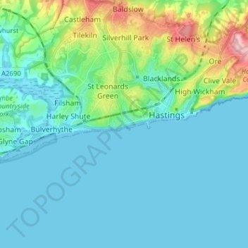
Name: St Leonards topographic map, elevation, terrain.
Average elevation: 30 m
Minimum elevation: -1 m
Maximum elevation: 173 m
Other topographic maps
Click on a map to view its topography, its elevation and its terrain.
Highwoods SSSI
United Kingdom > England > East Sussex > Rother > Bexhill-on-Sea
Average elevation: 28 m
Punnetts Town Recreation Ground
United Kingdom > England > East Sussex > Wealden > Punnett's Town > Chapel Cross
Average elevation: 125 m
Crowborough
United Kingdom > England > East Sussex > Wealden
In the late 19th century, Crowborough was promoted as a health resort based on its high elevation, the rolling hills and surrounding forest. Estate Agents even called it "Scotland in Sussex". The town's golf course opened in 1895, followed by a fire station and hospital in 1900.
Average elevation: 146 m
Ashdown Forest
United Kingdom > England > East Sussex > Wealden
Ashdown Forest is an ancient area of open heathland occupying the highest sandy ridge-top of the High Weald Area of Outstanding Natural Beauty. It is situated 30 miles (48 km) south of London in the county East Sussex, England. Rising to an elevation of 732 feet (223 m) above sea level, its heights provide…
Average elevation: 117 m
Rye
United Kingdom > England > East Sussex > Rother > Playden
The town and its striking surroundings have frequently served as subject for painters, many of whose works are now on display in its art gallery. One of the earliest topographical panoramas, dating from the 17th century when the town was still an island port, is in the style of Hendrick Danckerts and on…
Average elevation: 7 m
East Sussex
United Kingdom > England > East Sussex
The chalk uplands of the South Downs occupies the coastal strip between Brighton and Eastbourne. There are two river gaps: the Rivers Ouse and Cuckmere. The Seven Sisters, where the Downs meet the sea, are the remnants of dry valleys cut into the chalk; they end at Beachy Head, 530 feet (162 m) above sea…
Average elevation: 44 m
Chalvington
United Kingdom > England > East Sussex > Wealden District > Chalvington
Average elevation: 19 m
Kingston Near Lewes
United Kingdom > England > East Sussex > Lewes > Kingston Near Lewes
Average elevation: 65 m
Frant Lakes
United Kingdom > England > East Sussex > Wealden > Bells Yew Green
Average elevation: 110 m
Heathfield Park
United Kingdom > England > East Sussex > Wealden > Cade Street
Average elevation: 132 m
Broadwater Warren Nature Reserve
United Kingdom > England > East Sussex > Wealden > Groombridge
Average elevation: 84 m