
Thank you for supporting this site ❤️
Make a donation
Make a donation
Allentown topographic map
Click on the map to display elevation.
Thank you for supporting this site ❤️
Make a donation
Make a donation
About this map
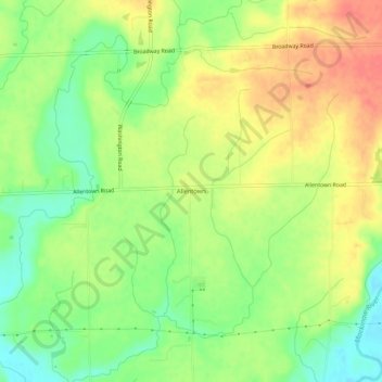
Name: Allentown topographic map, elevation, terrain.
Location: Allentown, Tazewell County, Illinois, United States (40.53587 -89.41676 40.57587 -89.37676)
Average elevation: 205 m
Minimum elevation: 176 m
Maximum elevation: 233 m
Thank you for supporting this site ❤️
Make a donation
Make a donation
Other topographic maps
Click on a map to view its topography, its elevation and its terrain.
Thank you for supporting this site ❤️
Make a donation
Make a donation
Thank you for supporting this site ❤️
Make a donation
Make a donation
Thank you for supporting this site ❤️
Make a donation
Make a donation